Details
Latitude-33.8101 Longitude151.004 Start Date1796 End Date1799
Description
A gaol was first established at Parramatta in 1796 (designed to hold just eight prisoners in single-use cells). Fire destroyed the initial building in 1799.
Details
Latitude-33.8028 Longitude151 Start Date1804 End Date1821
Description
The first Parramatta Female Factory was built near Parramatta Gaol, on what is now Prince Alfred Square. Within a decade, however, increasing numbers of convict women in the penal colony meant the facility was no longer adequate. A suitable site was found further up the Parramatta River for building a new female factory, which opened in 1821, allowing the closure of the first facility.
Sources
TLCMap IDt90f Linkback
Created At2021-02-17 13:37:19 Updated At2023-12-11 17:48:18
Details
Latitude-27.4708 Longitude153.023 Start Date1824 End Date1828
Description
Moreton Bay (later Brisbane) was established as a penal colony in 1824, used as a place of secondary transportation for hardened convicts who had been convicted of further offences after arriving in New South Wales. Upon arrival a temporary wooden building was established to house convicts on Queen Street (now the city's main thoroughfare), in the vicinity of today's Brisbane Square. It was used until stone structures were opened in 1828.
Sources
TLCMap IDt910 Linkback
Created At2021-02-17 13:37:19 Updated At2023-12-11 17:48:18
Details
Latitude-42.877 Longitude147.327 Start Date1821 End Date1829
Description
Due to the growing female convict population in Tasmania, in 1821 Governor Macquarie ordered that a small female factory be erected adjacent to the Hobart Town Gaol. The site's poor security led to frequent escapes from the factory during its years of operation, which ended in January 1829 when the final prisoners were transferred to the newly-built Cascades Female Factory. After the closure of the Female Factory in 1829 it was converted into shop premises.
Sources
TLCMap IDt911 Linkback
Created At2021-02-17 13:37:19 Updated At2023-12-11 17:48:18
Details
Latitude-42.3882 Longitude145.448 Start Date1822 End Date1833
Description
This penal station was established as a place for the worst convicts, particularly those who had escaped from other settlements. Despite its isolated condition, there were a considerable number of escape attempts from the island. Its most infamous escapee was Alexander Pearce, who managed to get away twice, and on both occasions cannibalised his fellow escapees. Convicts at the penal station were set to logging and shipbuilding, but the lack of suitable land for food production on the island led to high levels of malnutrition. Living conditions were also overcrowded and the imposition of floggings was common. Some prisoners preferred execution than a transfer to the island. The penal station was closed in 1833, with the remaining convicts transferred to Port Arthur. The settlement ruins - though not very well-preserved - are today a heritage site, along with the rest of the island.
Sources
TLCMap IDt912 Linkback
Created At2021-02-17 13:37:19 Updated At2023-12-11 17:48:18
Details
Latitude-41.1063 Longitude146.825 Start Date1822 End Date1834
Description
Initially this Female Factory where was simply a shed where female convicts would work at making woollen cloth and leather shoes during the day, then find lodging wherever they could in town at night. This changed in 1825, when the Factory was moved to the property of Reverend John Youl, and the women were housed onsite. However, as at the Hobart Female Factory, security on the site was poor, leading to riots and escape attempts. The operation closed in 1834, with the remaining prisoners sent to the Launceston Female Factory.
Sources
TLCMap IDt913 Linkback
Created At2021-02-17 13:37:19 Updated At2023-12-11 17:48:18
Details
Latitude-27.4674 Longitude153.028 Start Date1829 End Date1834
Description
A Female Factory was established at the Moreton Bay penal colony in 1829. As many as 138 women convicts lived and worked within this small building, many employed picking oakum from frayed ropes. The Moreton Bay Female Factory ceased being used as a convict establishment in 1834, when all the female convicts were transferred to Eagle Farm. The building?became Brisbane's first prison in 1850, then a police court. Today it is the site of Queen Street's General Post Office.
Sources
TLCMap IDt914 Linkback
Created At2021-02-17 13:37:19 Updated At2023-12-11 17:48:18
Details
Latitude-27.4436 Longitude153.09 Start Date1834 End Date1839
Description
The suburb now known as Eagle Farm in Brisbane started to be cleared for agricultural cultivation by convicts in the Moreton Bay penal colony in 1829. By 1934, some of the women convicts had been moved there, working in the fields and as dairywomen. Stationing female convicts at Eagle Farm was also an attempt to reduce their fraternisation with male convicts and the military. In 1836, the construction of slab cells at Eagle Farm was undertaken, and the following year all remaining female prisoners in Brisbane were removed to Eagle Farm. In 1839, all remaining convict women were shipped out of Moreton Bay penal colony to Sydney, closing the Eagle Farm prison. Only the foundations of the prison survive.
Sources
TLCMap IDt915 Linkback
Created At2021-02-17 13:37:19 Updated At2023-12-11 17:48:18
Details
Latitude-33.8101 Longitude151.004 Start Date1802 End Date1842
Description
A second gaol was built on the same site as the previously burned down gaol in 1802. Construction work was supervised by Parramatta magistrate Reverend Samuel Marsden, known as the flogging parson. The facility accommodated both male and female prisoners,. It quickly became overcrowded, and would experience further deterioration over the next 30 years.
Details
Latitude-27.4708 Longitude153.023 Start Date1828 End Date1842
Description
Built of stone, the prisoners' barracks at Moreton Bay was the largest building in the area when they opened in 1828, having accommodation for 1,000 convicts. The Moreton Bay penal colony and its barracks? closed in 1842.
Sources
TLCMap IDt917 Linkback
Created At2021-02-17 13:37:19 Updated At2023-12-11 17:48:18
Details
Latitude-33.8693 Longitude151.213 Start Date1819 End Date1847
Description
Upon opening in 1819, the Hyde Park Barracks provided accommodation for male convicts transported to the New South Wales penal colony. It ceased to be used for this purpose in 1848, becoming instead an Immigration Depot for newly-arrived female migrants. From 1862 it was an asylum for destitute women. In 1887 it was converted into law courts, operating as such until 1979. Today the Hyde Park Barracks operates as a history museum.
Sources
TLCMap IDt918 Linkback
Created At2021-02-17 13:37:19 Updated At2023-12-11 17:48:18
Details
Latitude-33.7987 Longitude151.001 Start Date1821 End Date1848
Description
This purpose-built facility was used to house convict women until they could be assigned to service in a respectable family, and also as a place of detention for those who had broken regulations while in assigned service. The factory also acted as a prison for women who committed a crime in the colony. Linen, wool and linsey woolsey were manufactured on site, with women also set to spinning, knitting, straw plaiting, washing, cleaning duties, rock breaking and oakum picking. In 1827, the factory was the site of Australia's first industrial action when women rioted in response to a cut in their rations. With the end of convict transportation to the colony, the site was converted into a lunatic and invalid asylum in 1848. Today the buildings form part of the Cumberland Hospital and New South Wales Institute of Psychiatry.
Sources
TLCMap IDt919 Linkback
Created At2021-02-17 13:37:19 Updated At2023-12-11 17:48:18
Details
Latitude-42.9882 Longitude147.717 Start Date1833 End Date1848
Description
Located about 23 kilometres from Port Arthur, the Saltwater River Penal Colony consisted of both an agricultural settlement and a coal mine, known for its particularly hellish working conditions. The penal colony closed in 1848. The ruins of the convict buildings at the Coal Mines Historic Site now fall under the administration of Port Arthur, and can be explored via a walking trail through the area.
Sources
TLCMap IDt91a Linkback
Created At2021-02-17 13:37:19 Updated At2023-12-11 17:48:18
Details
Latitude-37.903 Longitude144.861 Start Date1852 End Date1853
Description
The ship President was purchased and fitted out as a floating prison in 1852, to deal with Victoria's growing prison population following the discovery of gold in the colony brought a massive influx of migrants. It was only used a short time before four other prison hulks were purchased and put into use.?In 1885 the ship was broken up, its use as a prison having been previously discontinued.
Sources
TLCMap IDt91b Linkback
Created At2021-02-17 13:37:19 Updated At2023-12-11 17:48:18
Details
Latitude-42.0333 Longitude147.494 Start Date1848 End Date1854
Description
Built in the early 1940s as a probation station for male convicts working on road gangs, the Ross site was converted into a workhouse for female convicts in 1848. The Police Department took over the buildings after the factory closed in 1854. Today the only remaining building is the Overseer's Cottage, which contains a historical display about the site that is open to the public.
Sources
TLCMap IDt91c Linkback
Created At2021-02-17 13:37:19 Updated At2023-12-11 17:48:18
Details
Latitude-31.9558 Longitude115.862 Start Date1830 End Date1855
Description
A six-cell lockup was built in Perth the year after the founding of the Swan River Colony (later Western Australia). Following the completion of the prison Round House at Fremantle in 1831, it?was used to accommodate inmates only for short terms. The gaol was demolished in 1855, as its position opposite Government House was considered poorly located. It became the site of The Deanery, a residence for the first Dean of Perth, Reverend George Pownall, with this heritage-listed building?today offices for the Anglican Church.
Sources
TLCMap IDt91d Linkback
Created At2021-02-17 13:37:19 Updated At2023-12-11 17:48:18
Details
Latitude-41.4397 Longitude147.133 Start Date1834 End Date1855
Description
Opened as a work-house for female convicts, the site operated as a female factory until 1855. It then operated as a gaol until 1914, when it was demolished to build Launceston High School (today Launceston College).
Sources
TLCMap IDt91e Linkback
Created At2021-02-17 13:37:19 Updated At2023-12-11 17:48:18
Details
Latitude-38.3521 Longitude141.608 Start Date1842 End Date1855
Description
The first gaol was established in Portland around 1842. This small facility eventually grew insufficient for the town's need, and closed with the opening of a new gaol in 1855.
Sources
TLCMap IDt91f Linkback
Created At2021-02-17 13:37:19 Updated At2023-12-11 17:48:18
Details
Latitude-37.903 Longitude144.861 Start Date1853 End Date1855
Description
HMS Deborah was purchased in 1853 to act as a prison hulk. In 1855 the prisoners on Deborah were transferred to the hulk Lysander, and the Deborah was held as reserve gaol accommodations. From 1856 it was used as?a storage facility, before become a reformatory for male juvenile offenders in 1864. It continued to receive reformatory boys until 1873. After that for a while it was used to store and experiment with torpedoes, before being broken up in 1885.?
Sources
TLCMap IDt920 Linkback
Created At2021-02-17 13:37:19 Updated At2023-12-11 17:48:18
Details
Latitude-42.8937 Longitude147.299 Start Date1828 End Date1856
Description
This purpose-built workhouse for female convicts operated from 1828 to 1856. Female transportees would be housed there upon their first arrival in the colony until they could be sent out to assigned service with an appropriate family; assigned women would also be returned to the factory for disobedience or rule-breaking. The factory's location in a damp, swampy area led to high rates of disease among inmates, exacerbated by overcrowding. In 1869, more than a decade after its use as a female convict factory had ceased, the site became a reformatory for boys who were homeless or had been convicted of offences by the courts. At the reformatory boys would receive a basic education, work on farmland attached to the institution, or be apprenticed out to employers. The reformatory closed in 1876, but in 1884 the site was again opened as an alternative facility to prison for juvenile offenders, now known as the Boys' Training School. The Boys' Training School was transferred to a new site in New Town in 1896. Today the remaining Cascades buildings form a heritage site that is open to the visiting public.
Sources
TLCMap IDt921 Linkback
Created At2021-02-17 13:37:19 Updated At2023-12-11 17:48:18
Details
Latitude-37.903 Longitude144.861 Start Date1854 End Date1860
Description
The last of five ships that were purchased for use as prison hulks by the colony of Victoria during this period. In 1885 the ship was ordered to be broken up, its use as a prison having been previously discontinued.
Sources
TLCMap IDt922 Linkback
Created At2021-02-17 13:37:19 Updated At2023-12-11 17:48:18
Details
Latitude-37.0636 Longitude144.22 Start Date1852 End Date1861
Description
With the influx of migrants to the goldfields at Castlemaine in the 1850s, there was a pressing need for a prison to service the local area. The existing police watch-house building was therefore declared a prison in 1852, so that it could be used as a place where sentences could be served (rather than just hold those under arrest). However, within the decade it became clear that a purpose-built prison was required to house the growing number of inmates, leading to the old gaol's closing when a new facility opened at Castlemaine in 1861.
Sources
TLCMap IDt923 Linkback
Created At2021-02-17 13:37:19 Updated At2023-12-11 17:48:18
Details
Latitude-37.903 Longitude144.861 Start Date1853 End Date1868
Description
The Success was purchased along with the other hulks?to cope with the increased population and crime that followed the discovery of gold in Victoria. In 1857, convicts from the?Success?murdered Superintendent of Prisons?John Price. The hulk was later used to receive female prisoners until 1868. It was then put to various governmental purposed until 1890, when it was outfitted as a travelling museum about convict life. This display was not a commercial success, and the ship was scuttled, but was then refloated in 1893, with the convict museum travelling around the world, including to San Francisco in 1915 for the Panama-Pacific International Exposition. A fire destroyed the ship in 1945.
Sources
TLCMap IDt924 Linkback
Created At2021-02-17 13:37:19 Updated At2023-12-11 17:48:18
Details
Latitude-27.4129 Longitude153.145 Start Date1865 End Date1871
Description
In 1865 the ship Proserpine was acquired by the Queensland government and outfitted as a prison hulk to provide accommodation for inmates, due to overcrowding at the Petrie Terrace Gaol. In 1871 it was repurposed to act as a reformatory school for boys aged under 18 years. The reformatory was relocated to a new facility at Lytton in 1881.
Sources
TLCMap IDt925 Linkback
Created At2021-02-17 13:37:19 Updated At2023-12-11 17:48:18
Details
Latitude-43.137 Longitude147.846 Start Date1830 End Date1877
Description
Port Arthur was used as a penal colony for transported convicts from 1833 until the cessation of transportation in 1853. Juvenile convicts were also received at Port Arthur at the Point Puer prison, which received boys as young as nine.?Port Arthur was considered a particularly secure location, being both remote and surrounded by water on three sides. The site continued to be used as a prison after the cessation of transportation, with Port Arthur prison considered a model of the "Silent System" in which prisoners were kept separate from each other at all times.?This led to high rates of mental illness among inmates. The prison closed in 1877. Today it is a heritage site that is open to the visiting public.
Sources
TLCMap IDt926 Linkback
Created At2021-02-17 13:37:19 Updated At2023-12-11 17:48:18
Details
Latitude-37.903 Longitude144.861 Start Date1853 End Date1878
Description
During the 1850s Victoria purchased a number of sailing ships to act as prison hulks, including the Sacramento. Its use as a prison hulk ended in 1878.
Sources
TLCMap IDt927 Linkback
Created At2021-02-17 13:37:19 Updated At2023-12-11 17:48:18
Details
Latitude-34.5088 Longitude144.843 Start Date1870 End Date1880
Description
The police watch-house in Lachlan Street at Hay was proclaimed a police gaol in 1870. It was used to detain short-term prisoners or those awaiting trial. The construction of a new gaol at Hay in 1880 led to its closure. The site was later used as the Hay Post Office.
Sources
TLCMap IDt928 Linkback
Created At2021-02-17 13:37:19 Updated At2023-12-11 17:48:18
Details
Latitude-31.088 Longitude150.93 Start Date1861 End Date1881
Description
A gaol for short-sentence prisoners operated at Tamworth from at least 1861. This initial facility closed with the opening of new premises for Tamworth Gaol in Johnston Street in 1881.
Sources
TLCMap IDt929 Linkback
Created At2021-02-17 13:37:19 Updated At2023-12-11 17:48:18
Details
Latitude-34.1058 Longitude141.919 Start Date1870 End Date1881
Description
In 1870 the police watch-house in Wentworth's Darling Street was proclaimed a prison, enabling it to be used to confine prisoners sentenced to terms of 14 days or less. The gaol only had accommodation for 9 prisoners, and from 1875 there were complaints of overcrowding and of prisoners having to be chained up outside as there was no room for them. Plans were made for a gaol at a new site in Wentworth, leaving this facility to return to its former use as a police watch-house in 1881.
Sources
TLCMap IDt92a Linkback
Created At2021-02-17 13:37:19 Updated At2023-12-11 17:48:18
Details
Latitude-30.329 Longitude149.786 Start Date1870 End Date1882
Description
In 1870, the local watch-house at Narrabri was proclaimed a gaol. In 1882, the completion of a new prison at a different site in Narrabri allowed the old gaol to return to its former purpose as a watch-house.
Sources
TLCMap IDt92b Linkback
Created At2021-02-17 13:37:19 Updated At2023-12-11 17:48:18
Details
Latitude-27.4651 Longitude153.013 Start Date1860 End Date1883
Description
Almost from its opening in 1860, Brisbane Gaol on Petrie Terrace was overcrowded. In 1867 the quarantine station on St Helena Island started to be used as a gaol to relieve the strain, and in 1870 female prisoners at Petrie Terrace were relocated to the Toowoomba Gaol. The Petrie Terrace Gaol was finally able to close in 1883 with the completion of the Boggo Road Gaol in South Brisbane. The Petrie Terrace site was used as a police barracks from 1885 until the mid-1980s, as well as a training centre for the Queensland Defence Force. Many of the former police buildings remain intact, but have since been redeveloped as a retail and commercial precinct named The Barracks.
Sources
TLCMap IDt92c Linkback
Created At2021-02-17 13:37:19 Updated At2023-12-11 17:48:18
Details
Latitude-34.7533 Longitude149.722 Start Date1847 End Date1884
Description
A police lock-up was first built at Goulburn around 1830, but it was not proclaimed a gaol until 1847. A new prison complex was opened at Goulburn in 1884, leading this gaol to be closed.
Sources
TLCMap IDt92d Linkback
Created At2021-02-17 13:37:19 Updated At2023-12-11 17:48:18
Details
Latitude-33.4181 Longitude149.579 Start Date1830 End Date1888
Description
The first gaol at Bathurst opened in 1830, adjacent to the Bathurst Court House. Construction of a new gaol led to the earlier site's closure in 1888.
Sources
TLCMap IDt92e Linkback
Created At2021-02-17 13:37:19 Updated At2023-12-11 17:48:18
Details
Latitude-31.9496 Longitude115.862 Start Date1854 End Date1888
Description
The transportation of convicts to Western Australia from 1850 provided a labour force for public works, and a need for a facility to house inmates near the city. Initially the gaol was used for colonially-convicted prisoners, but from 1858 such prisoners were transferred to Fremantle Prison and Perth Gaol was used as accommodation for convicts transported from Britain. In 1875 the gaol reverted to use as a prison for locally-convicted inmates, following the cessation of transportation to Western Australia in 1868.?By 1886 there were reports that the gaol was overcrowded, and the prison closed in 1888. Since 1891 the building has been used as a museum, originally for geological and natural history artefacts. The gaol now forms part of the larger Western Australian museum complex, sitting behind the main building.
Sources
TLCMap IDt92f Linkback
Created At2021-02-17 13:37:19 Updated At2023-12-11 17:48:18
Details
Latitude-38.3516 Longitude141.608 Start Date1855 End Date1893
Description
The Portland Gaol Stockade opened in 1855, and in 1856 prisoners were put to work constructing roads. The gaol closed in 1893, and was demolished in 1938, except for part of the surrounding wall.
Sources
TLCMap IDt930 Linkback
Created At2021-02-17 13:37:19 Updated At2023-12-11 17:48:18
Details
Latitude-33.6644 Longitude138.933 Start Date1856 End Date1894
Description
The first prison built in South Australia outside the capital of Adelaide, Redruth opened in 1856. Initially it received few prisoners, but was experiencing overcrowding by 1876, with 22 prisoners within 8 cells. In 1894, the poor state of the buildings and low numbers of prisoners led to the decision to close the prison. It was reopened as a girls reformatory in 1897, continuing as such until 1922, after a riot by inmates the previous year had seen criticism of the staff and facility. Redruth Gaol underwent restoration in the late 1980s, and today operates as a?museum.
Sources
TLCMap IDt931 Linkback
Created At2021-02-17 13:37:19 Updated At2023-12-11 17:48:18
Details
Latitude-33.60560766 Longitude150.82552852 Start Date1859 End Date1899
Description
The Windsor police watch-house was constructed in 1821, and by 1835 was listed as being able to accommodate 50 inmates detained by police. The watch-house was proclaimed a gaol in 1859.? The? gaol closed in 1899. It was demolished in 1836.
Sources
TLCMap IDt932
Created At2021-02-17 13:37:19 Updated At2024-04-08 08:12:25
Details
Latitude-32.0559 Longitude115.741 Start Date1831 End Date1900
Description
The first permanent building of the Swan River Colony, which had been established two years earlier in 1829, the Round House at Fremantle is today the oldest extant building in Western Australia. Based on Jeremy Bentham's Panopticon design, the prison consisted of eight cells and a gaoler's residence. It was used to house colonial and Indigenous prisoners until 1886, when convicted locals began being sent to Fremantle Prison (formerly a prison for convict transportees) instead. The Round House remained in use as a police lockup until 1900. Today the site is a heritage tourist attraction.
Sources
TLCMap IDt933 Linkback
Created At2021-02-17 13:37:19 Updated At2023-12-11 17:48:18
Details
Latitude-32.0043 Longitude115.516 Start Date1838 End Date1902
Description
Rottnest Island was first used as a prison by colonial authorities in 1838 when six Aboriginal prisoners were sent there under the superintendence of a small military force. The following year?it was announced that the island would thenceforth be used as a prison for Aboriginal offenders. In 1881, a reformatory for boys was also opened on the island.?Some 3,700 Aboriginal men and boys were imprisoned at Rottnest Island across the facility's duration, with the reformatory closing in 1901 and the prison closing in 1902.?It was used as an internment camp during both World Wars. During the late twentieth century the former prison cells were used as tourist holiday accommodation, but in May 2018 the prison site, known as the 'Quod', was handed back to the Rottnest Island Authority. It has been suggested that the site may become a museum to the prison's history.?
Sources
TLCMap IDt934 Linkback
Created At2021-02-17 13:37:19 Updated At2023-12-11 17:48:18
Details
Latitude-27.4591 Longitude153.035 Start Date1863 End Date1903
Description
From its opening in 1863 Fortitude Valley Gaol was used to accommodate female prisoners from Brisbane who were serving short sentences; women serving longer sentences were transferred to the gaol at Toowoomba. The gaol closed in 1904, after the opening of a new women's prison at Boggo Road Gaol in Brisbane made it superfluous.
Sources
TLCMap IDt935 Linkback
Created At2021-02-17 13:37:19 Updated At2023-12-11 17:48:18
Details
Latitude-27.5624 Longitude151.962 Start Date1864 End Date1903
Description
Toowoomba Gaol opened in 1864 to receive inmates from the immediate area. In 1870 it began receiving female inmates from throughout southern Queensland, including?the capital of Brisbane. In 1881 a reformatory and industrial school for adolescent girls was opened adjacent to the prison. In 1887 the Royal Commission into Queensland prisons heavily criticised the gaol, declaring that 'no woman can enter Toowoomba Gaol without becoming degraded, losing self-respect, and made infinitely worse than before she stepped within its walls'.?Both the prison and reformatory?closed in 1903.?Today only the gaol foundations remain.
Sources
TLCMap IDt936 Linkback
Created At2021-02-17 13:37:19 Updated At2023-12-11 17:48:18
Details
Latitude-31.2735 Longitude149.278 Start Date1878 End Date1903
Description
Coonabarabran Gaol was a police gaols used for prisoners with sentences of 14 days or less. It closed in 1903.
Sources
TLCMap IDt937 Linkback
Created At2021-02-17 13:37:19 Updated At2023-12-11 17:48:18
Details
Latitude-30.8772 Longitude153.07 Start Date1886 End Date1903
Description
Trial Bay Gaol opened in 1886, after a decade of construction during which prisoners were housed in temporary wooden barracks. The prison closed in 1903 and the site remained unused until 1915, when it became an internment camp for German prisoners and resident 'enemy aliens' for the duration of World War One. In 1922 the gaol's interior fittings were stripped and sold off. The gaol ruins are now part of the Arakoon National Park, and can be visited as part of tours run by the Park.
Sources
TLCMap IDt938 Linkback
Created At2021-02-17 13:37:19 Updated At2023-12-11 17:48:18
Details
Latitude-34.4388 Longitude148.715 Start Date1889 End Date1904
Description
The Burrowa Gaol opened in 1889. It is unclear when it closed, but the last records from it date to 1904.
Sources
TLCMap IDt939 Linkback
Created At2021-02-17 13:37:19 Updated At2023-12-11 17:48:18
Details
Latitude-33.8959 Longitude148.161 Start Date1877 End Date1905
Description
Grenfell Gaol was a police gaol used for prisoners sentenced to 14 days or less. It closed in 1905.
Sources
TLCMap IDt93a Linkback
Created At2021-02-17 13:37:19 Updated At2023-12-11 17:48:18
Details
Latitude-33.0897 Longitude147.152 Start Date1902 End Date1905
Description
This gaol that received inmates sentenced to short prison terms?from 1902 until 1905, when it reverted to its original use as a a police watch-house.?
Sources
TLCMap IDt93b Linkback
Created At2021-02-17 13:37:19 Updated At2023-12-11 17:48:18
Details
Latitude-33.8476 Longitude151.171 Start Date1841 End Date1909
Description
Cockatoo Island was declared?a gaol in 1839 due to the imminent closure of the Norfolk Island convict establishment. Convict barracks were built, and became occupied in 1841. In 1869 the remaining prisoners were transferred from the Island to Darlinghurst Gaol, and the prison buildings became the Biloela industrial school and reformatory for delinquent girls from 1871. Following the closure of the Biloela reformatory in 1888, male prisoners were again sent to the island. The gaol continued to function until 1909. The Cockatoo Island Prison Barracks Precinct is now a heritage site and is open to the visiting public.
Details
Latitude-32.5897 Longitude149.582 Start Date1862 End Date1909
Description
Mudgee Gaol was opened as a police gaol for short-sentence prisoners in 1862. It closed in 1909.
Sources
TLCMap IDt93d Linkback
Created At2021-02-17 13:37:20 Updated At2023-12-11 17:48:18
Details
Latitude-35.4376 Longitude149.801 Start Date1862 End Date1909
Description
The gaol at Braidwood was opened?in 1862 for the purpose of detaining short-term offenders. It ceased operations in 1909.
Sources
TLCMap IDt93e Linkback
Created At2021-02-17 13:37:20 Updated At2023-12-11 17:48:18
Details
Latitude-35.1056 Longitude147.371 Start Date1862 End Date1909
Description
Newly erected premises at Wagga Wagga were declared a gaol in 1862. It was used for short-sentence prisoners (both men and women)?from the district, and by 1877 had accommodations for 41 inmates. The prison closed in 1909 and was demolished a decade later.??
Sources
TLCMap IDt93f Linkback
Created At2021-02-17 13:37:20 Updated At2023-12-11 17:48:18
Details
Latitude-34.8408 Longitude148.909 Start Date1863 End Date1909
Description
From its establishment in 1863, Yass Gaol was used as a minor gaol to accommodate short-sentence prisoners in the district. It was abolished in 1909.
Sources
TLCMap IDt940 Linkback
Created At2021-02-17 13:37:20 Updated At2023-12-11 17:48:18
Details
Latitude-36.2331 Longitude149.122 Start Date1867 End Date1909
Description
The first reference to Cooma Gaol appears to be the appointment of Robert Dawson as a Visiting Justice on 7 August, 1867. At about the same time an acting gaoler and a warder were appointed by the Sheriff. Early references refer to the Gaol as a 'Lock-Up'. During 1883 (the first year for which figures are available) 89 priosoners were admtted to the Gaol and 82 were discharged. The Gaol had 5 cells for separated and 15 for associated prisoners. The gaol was listed in the second schedule of Prisons Act 1899 as one of public gaols, prisons and houses of correction in existence. The Gaol was closed on 16 August 1909, by proclamation as one among several totally unsuitable for the proper treatment of any but the shortest sentenced prisoners. Another gaol was erected at Cooma in 1953 taking priosners from 1957
Sources
TLCMap IDt941 Linkback
Created At2021-02-17 13:37:20 Updated At2023-12-11 17:48:18
Details
Latitude-33.9239 Longitude147.205 Start Date1899 End Date1909
Description
Proclaimed a prison in 1899, Wyalong Gaol ceased to be a prison by proclamation in 1909.
Sources
TLCMap IDt942 Linkback
Created At2021-02-17 13:37:20 Updated At2023-12-11 17:48:18
Details
Latitude-23.7277 Longitude133.864 Start Date1904 End Date1909
Description
This small wooden police hut was the first prison in Central Australia. The first prisoners committed there were eight Aboriginal males (including two boys aged 14 and 16), who had been convicted of 'larceny of beef' or cattle killing. Sentences in the group ranged from 14 days hard labour for the two teenage boys to up to 6 months hard labour for the adults. All six escaped from the gaol but were eventually recaptured. The Heavitree Gap Gaol closed in 1909 when the purpose-built Stuart Town Gaol opened. The wooden gaol hut no longer exists, but restored stone buildings associated with the police station were declared a historical reserve in 1979.
Sources
TLCMap IDt943 Linkback
Created At2021-02-17 13:37:20 Updated At2023-12-11 17:48:18
Details
Latitude-31.4285 Longitude152.91 Start Date1859 End Date1912
Description
Between 1859 and 1912, this gaol acted as a police lock-up for prisoners serving short terms of 14 days or less.
Sources
TLCMap IDt944 Linkback
Created At2021-02-17 13:37:20 Updated At2023-12-11 17:48:18
Details
Latitude-33.8793 Longitude151.218 Start Date1841 End Date1914
Description
Construction on the gaol began in 1822 using convict labour, but the site was abandoned for over a decade before the funds were found to complete some of the cell blocks, allowing the first prisoners to be received in 1841.?76 people were hanged at the gaol during its period of usage, including bushranger Andrew George Scott aka "Captain Moonlite", and the last woman executed in New South Wales,?Louisa Collins, hanged in 1889 for poisoning her husband. The gaol closed in 1914, following the construction of new facilities at Long Bay Gaol. Darlinghurst Gaol was used as an internment cap during World War One, and since 1921?the site has been inhabited by the National School of Art.
Details
Latitude-34.4241 Longitude150.896 Start Date1874 End Date1915
Description
Wollongong Gaol operated as a prison for short-sentence prisoners from 1874 to 1915. It was demolished after World War One.
Sources
TLCMap IDt946 Linkback
Created At2021-02-17 13:37:20 Updated At2023-12-11 17:48:18
Details
Latitude-41.4398 Longitude147.134 Start Date1827 End Date1917
Description
This gaol was built in Paterson Street, Launceston to accommodate convicts sent as labour to colonists in northern Tasmania, as well as receive locally-convicted prisoners from the surrounding area. After the cessation of transportation in 1853, it was mainly converted to the latter purpose, receiving men, women and children as prisoners. By 1900, it was being used only for short-sentence prisoners. In 1917, it ceased operations with the construction of a police watch-house a few blocks away.
Sources
TLCMap IDt947 Linkback
Created At2021-02-17 13:37:20 Updated At2023-12-11 17:48:18
Details
Latitude-31.5606 Longitude143.376 Start Date1881 End Date1917
Description
This two-storey building was purpose-built as a gaol and opened in 1881 to accommodate short-sentence prisoners from the surrounding area. In 1917 the gaol closed in response to falling prison numbers. Today it is the site of the Wilcannia Police Station.?
Sources
TLCMap IDt948 Linkback
Created At2021-02-17 13:37:20 Updated At2023-12-11 17:48:18
Details
Latitude-42.7361 Longitude147.44 Start Date1825 End Date1920
Description
This gaol was established as colonists moved away from Hobart Town in search of more farming land, bringing with them convicts to act as unpaid labour. The township of Richmond was proclaimed in 1824, with the gaol and a courthouse opening the following year. The small gaol was often overcrowded, with prisoners forced to sleep in the passageways. After the cessation of convict transportation, the gaol was simply used as holding cells by the local police, before being entirely abandoned in 1920s. Today the gaol is a heritage site open to visitors.
Sources
TLCMap IDt949 Linkback
Created At2021-02-17 13:37:20 Updated At2023-12-11 17:48:18
Details
Latitude-30.5233 Longitude151.66 Start Date1863 End Date1920
Description
Armidale Gaol opened in 1863 as a minor police gaol for receiving prisoners from the district sentenced to a term of 12 months imprisonment or less. Declining numbers of prisoners led to the gaol's closure in 1920. In 1927 the gaol was demolished and the Armidale Teachers' College was subsequently erected on the site.
Sources
TLCMap IDt94a Linkback
Created At2021-02-17 13:37:20 Updated At2023-12-11 17:48:18
Details
Latitude-34.3617 Longitude148.291 Start Date1870 End Date1923
Description
The police watch-house at Young was proclaimed a prison in 1870 and was used as a police gaol for detaining prisoners sentenced to short terms. It closed in 1923. Much of the gaol was demolished in 1934, and the remains were incorporated into Young's technical college.
Sources
TLCMap IDt94b Linkback
Created At2021-02-17 13:37:20 Updated At2023-12-11 17:48:18
Details
Latitude-26.5695 Longitude148.773 Start Date1872 End Date1923
Description
Roma Gaol was used to receive inmates convicted of minor offences resulting in sentences of 12 months or less. In 1903 it was reclassified from a prison to a police gaol that could only receive prisoners serving sentences of 30 days or less. It served in this capacity until 1923, when it was demolished.
Sources
TLCMap IDt94c Linkback
Created At2021-02-17 13:37:20 Updated At2023-12-11 17:48:18
Details
Latitude-37.8077 Longitude144.965 Start Date1845 End Date1924
Description
The gaol was established in 1845, but by 1850 it was already over-crowded, and the population influx brought by the discovery of gold in Victoria in 1851 quickly necessitated extensions (which were based on London's Pentonville Model Prison).?Detailed records of daily life inside the gaol are provided by the?diaries?of John Castieau, governor of the gaol between 1869 and 1884. Men, women and children were all imprisoned in the gaol. The youngest prisoner (not counting those infants born inside or accompanying their mothers) was a three-year-old convicted for being an idle and disorderly character in 1857. There were 135 hangings at the gaol, including infamous bushranger?Ned Kelly?and nineteenth-century serial killer?Frederick Bailey Deeming. The gaol was closed in 1924, although during World War Two it was used as a military prison. Although part of the gaol was demolished, today the remaining buildings operate as a prison museum.
Sources
TLCMap IDt94d Linkback
Created At2021-02-17 13:37:20 Updated At2023-12-11 17:48:18
Details
Latitude-18.6512 Longitude146.156 Start Date1886 End Date1924
Description
Ingham Gaol was opened in 1886; previously there had only been a police lock-up. The gaol closed in 1924.
Sources
TLCMap IDt94e Linkback
Created At2021-02-17 13:37:20 Updated At2023-12-11 17:48:18
Details
Latitude-16.9269 Longitude145.775 Start Date1897 End Date1925
Description
This prison was opened in 1897, replacing the Herberton Police Gaol. It closed in 1925 and the buildings were later demolished.
Sources
TLCMap IDt94f Linkback
Created At2021-02-17 13:37:20 Updated At2023-12-11 17:48:18
Details
Latitude-34.1025 Longitude141.913 Start Date1881 End Date1928
Description
Wentworth gaol opened in 1881 with accommodation for 18 prisoners. However, the erection of gaols at Goulburn, Silverton and Broken Hill across the subsequent decade decreased the need for Wentworth Gaol. The gaol closed in 1928. It was temporarily re-used in 1962 when riots in Midura prompted a need for the cells. It has been run as a tourist attraction since 1981.
Sources
TLCMap IDt950 Linkback
Created At2021-02-17 13:37:20 Updated At2023-12-11 17:48:18
Details
Latitude-42.639 Longitude148.066 Start Date1825 End Date1932
Description
Between 1825 and 1832, Maria Island operated as a penal colony that was conceived of as a compromise between the harsh conditions at Macquarie Harbour and the less stringent security of work in a chain gang building roads. Due to numerous escape attempts and disciplinary problems, the remaining convict population was relocated to Port Arthur in 1832. In 1842 the site was reopened as a probation station,??but was closed due to overcrowding in 1850. Today the island is a national park.
Sources
TLCMap IDt951 Linkback
Created At2021-02-17 13:37:20 Updated At2023-12-11 17:48:18
Details
Latitude-27.3887 Longitude153.233 Start Date1867 End Date1932
Description
In 1866, prisoners who were being kept aboard the prison hulk Proserpine began to be taken ashore St Helena Island each day to work on buildings intended to act as a new quarantine station. However, because the gaol facility at Petrie Terrace in Brisbane was becoming so congested, it was decided to use the buildings under construction as a gaol instead. Even after the opening of a new prison in Brisbane at Boggo Road in 1883, St Helena Island continued to be used as a secure prison for the colony's worst offenders, predominantly those convicted of serious violence. The prison closed in 1932. Today the island is a tourist destination, with visitors able to take guided tours about the prison's history.
Sources
TLCMap IDt952 Linkback
Created At2021-02-17 13:37:20 Updated At2023-12-11 17:48:18
Details
Latitude-34.6403 Longitude143.565 Start Date1887 End Date1932
Description
Balranald Gaol was a police gaol used for prisoners with sentences of 14 days or less. The daily number of prisoners at the gaol was 1918. It ceased to function as a prison in 1932 and today is a gaol museum.
Sources
TLCMap IDt953 Linkback
Created At2021-02-17 13:37:20 Updated At2023-12-11 17:48:18
Details
Latitude-35.5335 Longitude144.963 Start Date1864 End Date1935
Description
The purpose-built gaol at Deniliquin was constructed during 1863 and opened in 1864 to receive short-term prisoners. It closed in 1935 and was later demolished.
Sources
TLCMap IDt954 Linkback
Created At2021-02-17 13:37:20 Updated At2023-12-11 17:48:18
Details
Latitude-34.6402 Longitude148.024 Start Date1886 End Date1935
Description
Cootamundra Gaol was opened as a police gaol in 1886 for prisoners serving short sentences of 14 days or less. It closed in 1935.
Sources
TLCMap IDt955 Linkback
Created At2021-02-17 13:37:20 Updated At2023-12-11 17:48:18
Details
Latitude-23.6984 Longitude133.881 Start Date1909 End Date1938
Description
The Stuart Town Gaol was established in Parsons Street in?Alice Springs, then called Stuart, in 1909. It housed male and female inmates of all ages. There were two cells - one for European and one for Aboriginal prisoners. Numbers of prisoners were initially fairly low, but increased sharply after the railway reached Stuart in 1929. When the name of the town was changed to Alice Springs in 1933 the gaol became known as the Alice Springs Gaol. It closed in 1938 with the opening of the HM Gaol and Labour Prison Alice Springs at Stuart Terrace. Today the Stuart Town Gaol, the oldest surviving building in Alice Springs, houses memorabilia related to police history and life in Central Australia.
Sources
TLCMap IDt956 Linkback
Created At2021-02-17 13:37:20 Updated At2023-12-11 17:48:18
Details
Latitude-32.1528 Longitude152.499 Start Date1913 End Date1938
Description
The Tuncurry Afforestation camp, established in 1913, was the first prison of its kind in New South Wales. Its purpose was to provide prisoners with a more rehabilitative form of prison life and opportunities to engage in work that would offer skills that could be used to gain employment upon release. Tuncurry closed in 1938 and the camp was demolished.
Sources
TLCMap IDt957 Linkback
Created At2021-02-17 13:37:20 Updated At2023-12-11 17:48:18
Details
Latitude-36.9058 Longitude149.238 Start Date1892 End Date1939
Description
The police watch-house and lock-up at Bombala was proclaimed a public gaol in 1892 for the detention of prisoners sentenced at the local Court of Quarter Sessions. In its first year of operation it received a total of 26 prisoners. The gaol ceased to function as a prison in 1939.
Sources
TLCMap IDt958 Linkback
Created At2021-02-17 13:37:20 Updated At2023-12-11 17:48:18
Details
Latitude-36.6744 Longitude149.843 Start Date1874 End Date1940
Description
Bega Gaol began operations in 1874 with accommodation for 19 prisoners. It ceased to operate as a prison in 1940.
Sources
TLCMap IDt959 Linkback
Created At2021-02-17 13:37:20 Updated At2023-12-11 17:48:18
Details
Latitude-31.9132 Longitude152.457 Start Date1884 End Date1940
Description
Taree Gaol was established in 1884 with accommodations for 16 prisoners. It was used as a police gaol for prisoners sentenced to terms of 14 days or less. Taree Gaol ceased to operate as a prison in 1940.
Sources
TLCMap IDt95a Linkback
Created At2021-02-17 13:37:20 Updated At2023-12-11 17:48:18
Details
Latitude-31.079 Longitude152.831 Start Date1884 End Date1941
Description
Kempsey Gaol began receiving prisoners in 1884, taking in 48 prisoners its first year. It was a police gaol for prisoners serving sentences of 14 days or less. It ceased to function as a prison in 1941.
Sources
TLCMap IDt95b Linkback
Created At2021-02-17 13:37:20 Updated At2023-12-11 17:48:18
Details
Latitude-36.0781 Longitude146.908 Start Date1861 End Date1943
Description
The first reference to Albury Gaol in governmental records appears in 1861, although it could have been in operation slightly earlier. It was a minor gaol used for short-sentence prisoners from the local district. It ceased to function as a prison in 1943 and was demolished several years later.
Sources
TLCMap IDt95c Linkback
Created At2021-02-17 13:37:20 Updated At2023-12-11 17:48:18
Details
Latitude-31.885 Longitude141.225 Start Date1888 End Date1945
Description
Silverton Gaol was established at the mining town of Silverton outside Broken Hill in 1888. In its first few years it was heavily used, but this declined with the opening of a new gaol at Broken Hill?in 1892. It was thereafter only used for prisoners on very short sentences. By the 1930s it was only being used as a police station, and this closed in 1945. Today Silverton Gaol operates as a historical museum.
Sources
TLCMap IDt95d Linkback
Created At2021-02-17 13:37:20 Updated At2023-12-11 17:48:18
Details
Latitude-28.1394 Longitude153.227 Start Date1942 End Date1949
Description
One of several prison farms opened in Queensland in the 1930s and 1940s to rehabilitate minimum-security prisoners. This one was short-lived, closing down in 1949.
Sources
TLCMap IDt95e Linkback
Created At2021-02-17 13:37:20 Updated At2023-12-11 17:48:18
Details
Latitude-18.6845 Longitude145.999 Start Date1945 End Date1962
Description
Stone River Prison Farm closed in 1962.
Sources
TLCMap IDt95f Linkback
Created At2021-02-17 13:37:20 Updated At2023-12-11 17:48:18
Details
Latitude-42.877 Longitude147.327 Start Date1821 End Date1963
Description
Built by convict labour, this gaol was originally used to house male convicts, with accommodations for 640 men. However, extensions across the 1820s soon meant the gaol could house twice that figure. From 1846 it was increasingly used as a civilian prison, especially after the cessation of transportation to Tasmania in 1853. It was the site of 32 executions between 1857 and 1946. The gaol finally closed in 1963, following the establishment of a new facility, Risdon Prison,?a few years earlier. A small group of gaol buildings remain intact at the corner of Campbell and Brisbane Street, now known as the Penitentiary Chapel Historic Site, which is open to the visiting public.
Sources
TLCMap IDt960 Linkback
Created At2021-02-17 13:37:20 Updated At2023-12-11 17:48:18
Details
Latitude-37.6262 Longitude143.891 Start Date1862 End Date1965
Description
Ballarat Gaol opened in 1862, with accommodations for 74 inmates. It received male and female prisoners, as well as children. It continued to operate into the twentieth century as a maximum-security prison, finally closing in 1965. Most of the gaol was then demolished, with the few buildings that remain now used by Federation University.
Sources
TLCMap IDt961 Linkback
Created At2021-02-17 13:37:20 Updated At2023-12-11 17:48:18
Details
Latitude-32.2456 Longitude148.602 Start Date1847 End Date1966
Description
The Dubbo gaol began as a simple lockup attached to the courthouse in 1847; it was not proclaimed a gaol until 1859. The premises were expanded in 1871, and further upgraded in 1887.?Dubbo gaol continued to operate until 1966. Today the gaol operates as a tourist attraction.
Sources
TLCMap IDt962 Linkback
Created At2021-02-17 13:37:20 Updated At2023-12-11 17:48:18
Details
Latitude-34.503 Longitude144.851 Start Date1880 End Date1974
Description
In 1880 the Hay Gaol was moved from Lachlan Street to a new building in Church Street. It was mainly used to incarcerate short-term offenders from the surrounding districts. Low numbers of prisoners led to an ongoing struggle to keep the prison open, with a daily average of only 14 inmates in 1897. By 1915 the gaol had only 3 prisoners being supervised by a staff of 4. It was therefore closed that year. During the interwar period it was used as a hospital then maternity home, until over-crowding in the state's prisons led to its reopening as a gaol in 1930. In 1940 Hay Gaol again closed and was used as a prisoner-of-war and internment centre. After the war it was used as emergency public housing until 1961, when it became a maximum-security institution for girls aged 13 to 18 years, following wide scale rioting at the Parramatta Girls' Home earlier that year. The system at Hay was particularly harsh: girls were only allowed ten minutes twice a day to talk among themselves; they had to keep their eyes downcast at all times; had to keep at least six feet apart from each other at all times; raise their arms to talk to a staff member and await a response; and receive no schooling, instead put to work cleaning, cooking, scrubbing and painting walls, laying concrete paths, gardening and sewing. Those who misbehaved were put in an isolation block in the courtyard for a 24-hour period on bread and water. After negative media about the institution it closed in 1974. The gaol is now a museum and cultural centre.
Sources
TLCMap IDt963 Linkback
Created At2021-02-17 13:37:20 Updated At2023-12-11 17:48:18
Details
Latitude-33.345 Longitude138.413 Start Date1881 End Date1975
Description
Designed to house both male and female inmates, Gladstone Gaol was?based on a model prison plan by the then governor of Bristol Prison in England. By the 1920s, however, the gaol had a reputation for having particularly harsh conditions. In 1939 all prisoners in the gaol was transferred to Adelaide to enable the military to use the site as an internment camp, and then later a military detention barracks. The prison was reopened in 1952 and from that time was mostly used to house males under 25 years who it was felt needed to be kept away from the 'hardened criminals' elsewhere. The prison closed in 1975 due to the outdated nature of the facilities, and since 1978 has been open to visitors as a tourist attraction.
Sources
TLCMap IDt964 Linkback
Created At2021-02-17 13:37:20 Updated At2023-12-11 17:48:18
Details
Latitude-38.3647 Longitude145.445 Start Date1916 End Date1975
Description
The McLeod prison farm on French Island opened in 1916 as a tent village. Timber cabins housed prisoners until 1946 when concrete cells were built. It operated as a self-sustaining farm. The prison closed in 1975 and was used as a holiday camp facility until 1995, and now is privately owned.
Sources
TLCMap IDt965 Linkback
Created At2021-02-17 13:37:20 Updated At2023-12-11 17:48:18
Details
Latitude-12.4255 Longitude130.837 Start Date1883 End Date1979
Description
Fannie Bay Gaol in Darwin opened in 1883. Five years later Deputy Sheriff John George Knight collected drawings made by Aboriginal prisoners at the gaol and sent them for display at the Melbourne Centennial Exhibition, one of the earliest exhibitions of Aboriginal art. Women prisoners at the gaol were housed for many years in the Gaoler's residence, but in 1928 a female cellblock was constructed. The prison was damaged and temporarily closed when Cyclone Tracy hit Darwin in 1974. The gaol closed permanently in 1979, and is now a museum open to the public.
Sources
TLCMap IDt966 Linkback
Created At2021-02-17 13:37:20 Updated At2023-12-11 17:48:18
Details
Latitude-30.7461 Longitude121.473 Start Date1896 End Date1980
Description
The town of Kalgoorlie began to develop in 1893 after the discovery of gold nearby. Newspaper reports indicate that by 1896 a gaol was operating in the area and receiving short-sentence prisoners, although facility may have been in use from a slightly earlier date. By the mid twentieth century the gaol had become known as the Kalgoorlie Regional Prison. It closed in 1980 with the opening of the Eastern Goldfields Regional Prison.?
Sources
TLCMap IDt967 Linkback
Created At2021-02-17 13:37:20 Updated At2023-12-11 17:48:18
Details
Latitude-30.3285 Longitude149.786 Start Date1882 End Date1982
Description
In 1882, Narrabri Gaol was opened to receive short-sentence prisoners and those awaiting trial. The prison was closed in 1982. Today the gaol is operated as a museum and heritage centre by the Narrabri Historical Society.
Sources
TLCMap IDt968 Linkback
Created At2021-02-17 13:37:20 Updated At2023-12-11 17:48:18
Details
Latitude-34.9176 Longitude138.585 Start Date1841 End Date1988
Description
When British colonists first arrived in South Australia from 1836, they initially kept the occasional prisoners they had in irons aboard moored ships. A temporary wooden gaol was erected in 1838, a facility that quickly became over-crowded, necessitating a more permanent structure. This gaol, which had capacity to hold 140 prisoners,?was completed in 1841. Additions and renovations to the gaol occurred periodically across the twentieth century, until the gaol was eventually decommissioned in 1988. Today the gaol is a heritage site that is open to the public.
Sources
TLCMap IDt969 Linkback
Created At2021-02-17 13:37:20 Updated At2023-12-11 17:48:18
Details
Latitude-37.2796 Longitude142.959 Start Date1863 End Date1989
Description
Ararat Gaol, the design of which was based on London's Pentonville prison, opened in 1863. It was run as a gaol until 1886. Following some alterations, the former gaol was made a special ward of the Ararat Asylum in 1887. J Ward was used to accommodate persons convicted of crimes who were considered mentally unfit. It continued to be used for this purpose until 1989. Today it is the site of the Melbourne Polytechnic Ararat Training Centre, which runs a vineyard and winery where students can learn about the wine business. However, public tours detailing the history of gaol and asylum buildings are available by booking.
Sources
TLCMap IDt96a Linkback
Created At2021-02-17 13:37:20 Updated At2023-12-11 17:48:18
Details
Latitude-37.0621 Longitude144.211 Start Date1861 End Date1990
Description
This purpose-built prison was opened in 1861 to house all manner of prisoners, and was one of the few prisons outside Melbourne that received long-sentence inmates. However, by the turn of the century it was mainly being used to accomodate short-sentence prisoners and first-time offenders. In 1908 the gaol closed. For a while there were plans to transform into an institution for treating inebriates, many of whom during this period would otherwise be confined to gaols on charges of habitual drunkenness. Ultimately, in 1909 it was instead?converted into a reformatory school for males aged 16 to 25 years. The reformatory closed in 1951, with the facility reopening in 1954 as a gaol to accommodate medium-security prisoners. It closed for good in 1990. Today the gaol is open to the public as a tourist attraction.
Sources
TLCMap IDt96b Linkback
Created At2021-02-17 13:37:20 Updated At2023-12-11 17:48:18
Details
Latitude-38.1489 Longitude144.365 Start Date1853 End Date1991
Description
This gaol was built by prisoners who slept on hulks in Corio Bay during construction. In 1865 the gaol closed and was converted into an industrial school for girls who had committed minor offences or were considered to be at risk. The industrial school closed in 1872 and for five years the building was empty, but it became a hospital gaol?receiving invalid prisoners from 1877 until 1940. During the Second World War it was used as army detention barracks, before reverting to a hospital gaol in 1947. In 1958 the hospital gaol closed, and it was used as a training prison for medium-security prisoners until 1991. The gaol is now a museum.
Sources
TLCMap IDt96c Linkback
Created At2021-02-17 13:37:20 Updated At2023-12-11 17:48:18
Details
Latitude-32.0548 Longitude115.754 Start Date1855 End Date1991
Description
While Swan River Colony was initially established in 1829 as a 'free settlement', by 1850 the need for a larger labour force convicts led to the introduction of transportation of convicts from Britain to Western Australia. Fremantle Prison was established to provide accommodation for these overseas convicts; some locally-convicted inmates were also held there from 1858. Penal transportation to Western Australia ended in 1868 and the number of convicts under sentence in the colony then gradually declined, so the prison eventually came under colonial control in 1886. Locally-convicted men from Perth Gaol were transferred to Fremantle, and from 1887 female prisoners were also sent there. The discovery of gold in Western Australia in 1890s swelled the population and prison numbers, and in the early twentieth century the gaol was considerably enlarged. Nevertheless, in 1911 a Royal Commission into Fremantle Prison recommended closing the facility due to its outdated conditions, but this recommendation was not acted upon. During both world wars the prison was used for the detention of military personnel accused of crimes, as well as an internment centre for enemy aliens and prisoners of war. Female inmates were removed from Fremantle in 1970. Despite growing pressure for prison reform, Fremantle Prison was slow to modernise, eventually leading to a major riot by dissatisfied prisoners in 1988.?The prison closed in 1991 and today operates as a museum about the gaol's history.
Sources
TLCMap IDt96d Linkback
Created At2021-02-17 13:37:20 Updated At2023-12-11 17:48:18
Details
Latitude-27.4951 Longitude153.029 Start Date1883 End Date1992
Description
The first cellblock opened at Boggo Road in 1883 to receive male prisoners. In 1903 a prison was built at the site to hold female prisoners; this cellblock became known as the No. 2 Division, and is the only building that still exists?today. There were 42 hangings at Boggo Road Gaol before Queensland became the first part of the British Commonwealth to abolish capital punishment in 1922. New prison buildings replaced the old No. 1 Division in the 1960s. During the 1970s the gaol became notorious throughout Australia for its appalling conditions, which inspired a number of protests. The prison closed in 1992. Since then No. 2 Division has been home to the Boggo Road Gaol Museum. In 2010 the site was redeveloped into the Boggo Road Urban Village, although the heritage-listed No. 2 Division remains in place and can be visited by the public on tours that detail the gaol's history.
Sources
TLCMap IDt96e Linkback
Created At2021-02-17 13:37:20 Updated At2023-12-11 17:48:18
Details
Latitude-23.7041 Longitude133.877 Start Date1938 End Date1993
Description
A gaol opened in 1938 to accommodate both male and female prisoners (in separate cell blocks). The gaol was the Northern Territory's only correctional facility for a time following the bombing of Darwin in 1942, and again for a short time in 1974 when Darwin's Fannie Bay Gaol was damaged by Cyclone Tracy. Until 1964, male?inmates were?segregated by race within the facility.?Originally built to detain 22 prisoners, from the mid 1960s prison numbers rose sharply so that by 1975 there were 121 inmates in the gaol, even though the optimum number of prisoners the gaol had capacity for was estimated at 60. The high incarceration rates disproportionately involved Aboriginal offenders. In 1993 the gaol was closed, and after a brief battle between heritage organisations and private developers wanting to demolish the buildings, the complex was leased to the National Pioneer Women's Hall of Fame to open a museum that includes exhibitions about the site's prison history.
Sources
TLCMap IDt96f Linkback
Created At2021-02-17 13:37:20 Updated At2023-12-11 17:48:18
Details
Latitude-35.7239 Longitude148.493 Start Date1967 End Date1993
Description
Yarrangobilly Gaol closed in 1993.
Sources
TLCMap IDt970 Linkback
Created At2021-02-17 13:37:20 Updated At2023-12-11 17:48:18
Details
Latitude-37.8324 Longitude140.773 Start Date1866 End Date1995
Description
Mount Gambier Gaol opened in 1866, and became the longest running country gaol in South Australia, operating continuously until it closed in 1995. Today Mount Gambier Gaol operates as a tourist attraction, with visitors able to tour the buildings or even stay onsite, with a number of the cells having been converted into a hotel.
Sources
TLCMap IDt971 Linkback
Created At2021-02-17 13:37:20 Updated At2023-12-11 17:48:18
Details
Latitude-35.6438 Longitude148.07 Start Date1957 End Date1995
Description
This correctional centre consisted of a 750-acre camp aimed at providing prisoners with work skills in tree-planting and outdoor work. It closed in 1995.
Sources
TLCMap IDt972 Linkback
Created At2021-02-17 13:37:20 Updated At2023-12-11 17:48:18
Details
Latitude-37.797 Longitude145.015 Start Date1956 End Date1996
Description
A female prison built on the site of the former Yarra Bend Asylum, with remnants of the walls and gates incorporated into the prison layout. Between 1956 and 1982 the prison had an operational capacity of 60 inmates. In 1982 arson destroyed parts of the prison and led to the deaths of three inmates. The facility was rebuilt and expanded, reopening in 1986 with an operational capacity of 106 inmates. The prison closed in 1996.?
Sources
TLCMap IDt973 Linkback
Created At2021-02-17 13:37:20 Updated At2023-12-11 17:48:18
Details
Latitude-37.7371 Longitude144.968 Start Date1851 End Date1997
Description
The original prison building opened at Coburg in 1851, but underwent much extension and renovation in the late 1850s and early 1860s. The size of the complex expanded as different divisions were introduced to house different types of prisoners, with separate accommodations for prisoners of good behaviour, long-term prisoners with behaviour problems, short-term prisoners, remand prisoners, prisoners with psychiatric problems, high-security prisoners, young offenders and eventually maximum-security prisoners. A government reformatory for girls was also opened adjacent to the prison in 1864, but eventually closed in 1893, in part because it was felt that the reformatory's location so close to the prison was less than ideal. A reformatory for boys also operated in the grounds of Pentridge prison, known as the Jika Reformatory, from 1873 to 1879.?With the closure of Melbourne Gaol in 1924, Pentridge became the main prison for the metropolitan area. Pentridge eventually closed in 1997. The site is heritage-listed, and is currently undergoing remodelling that will turn it into an urban village.
Sources
TLCMap IDt974 Linkback
Created At2021-02-17 13:37:20 Updated At2023-12-11 17:48:18
Details
Latitude-38.1109 Longitude147.061 Start Date1887 End Date1997
Description
HM Prison Sale was completed in 1887 and operated for 110 years until its closure in 1997. The building has since been demolished, although some of the old prison walls remain part of the site, which now houses the Sale Police Station.
Sources
TLCMap IDt975 Linkback
Created At2021-02-17 13:37:20 Updated At2023-12-11 17:48:18
Details
Latitude-38.2161 Longitude146.367 Start Date1951 End Date1997
Description
A minimum-security, 100-bed?prison farm that offered inmates?far greater freedom than traditional prisons, allowing men to visit local shopping centres unattended and wear civilian clothes. It closed in 1997.
Sources
TLCMap IDt976 Linkback
Created At2021-02-17 13:37:20 Updated At2023-12-11 17:48:18
Details
Latitude-32.7449 Longitude151.59 Start Date1848 End Date1998
Description
Temporary gaol accommodations were used at this site from 1843, but permanent buildings were not commenced until 1846. Sixteen men were executed at the gaol between 1849 and 1897. The gaol became a maximum-security prison in 1972, and during the 1970s was the?scene of some notorious riots and escapes. The gaol closed in 1998 ant today operates as a tourist attraction.
Sources
TLCMap IDt977 Linkback
Created At2021-02-17 13:37:20 Updated At2023-12-11 17:48:18
Details
Latitude-23.3815 Longitude150.515 Start Date1969 End Date2001
Description
This prison closed in 2001, when it was replaced by the Capricornia Correctional Centre.
Sources
TLCMap IDt978 Linkback
Created At2021-02-17 13:37:20 Updated At2023-12-11 17:48:18
Details
Latitude-31.8677 Longitude115.969 Start Date1998 End Date2001
Description
Riverbank opened in 1960 as the first purpose-built maximum-security reformatory for boys, with accommodations for up to 33 teenage offenders. There was a significant emphasis on work-skills training, with an onsite factory that made a range of goods for charities, and the introduction of a computer-aided learning system from 1986. In 1996 the youth facility closed and was re-commissioned as an adult prison in 1998, which remained operational until 2001.
Sources
TLCMap IDt979 Linkback
Created At2021-02-17 13:37:20 Updated At2023-12-11 17:48:18
Details
Latitude-12.3861 Longitude132.128 Start Date1986 End Date2003
Description
A minimum-security, 20-bed facility for juvenile males located within the Mary River National Park. It was designed to promote the rehabilitation of juvenile detainees from remote Aboriginal communities. It closed in 2003.
Sources
TLCMap IDt97a Linkback
Created At2021-02-17 13:37:20 Updated At2023-12-11 17:48:18
Details
Latitude-36.3579 Longitude146.69 Start Date1860 End Date2004
Description
Beechworth Gaol opened in 1860 while still incomplete, with the buildings not finished until 1864. The prison was one of many built during this era on the radiating 'panopticon' principle to enable surveillance of prisoners by guards positioned in a central observation point. Declining prison numbers led to the gaol being closed in 1918, but in 1925 it was reopened as a reformatory for men designated 'habitual offenders', who under legislation at that time could be held indefinitely. In 1951 it was used instead as a training prison to provide rehabilitative employment and educational opportunities for more low to medium-security inmates. The facility closed in 2004, and today operates as a tourist attraction.
Sources
TLCMap IDt97b Linkback
Created At2021-02-17 13:37:20 Updated At2023-12-11 17:48:18
Details
Latitude-38.4767 Longitude146.716 Start Date1963 End Date2004
Description
A minimum-security, 127-bed prison that closed in 2004.
Sources
TLCMap IDt97c Linkback
Created At2021-02-17 13:37:20 Updated At2023-12-11 17:48:18
Details
Latitude-32.001 Longitude115.897 Start Date1998 End Date2004
Description
Nyandi was originally established in 1970 as a maximum-security female youth detention centre for up to 30 adolescent girls. From 1986, Nyandi also admitted boys aged 12-14 years. The youth detention centre closed in 1997, with the site re-opening the following year as a minimum-security prison for adult women. This correctional facility closed in 2004, and the buildings are now used for training Corrective Services staff.?
Sources
TLCMap IDt97d Linkback
Created At2021-02-17 13:37:20 Updated At2023-12-11 17:48:18
Details
Latitude-36.7542 Longitude144.28 Start Date1863 End Date2006
Description
When this prison first opened in 1863 it was called Sandhurst Gaol, as this was Bendigo's official name until 1891, although locally the town was already being referred to as Bendigo. The gaol originally housed up to 80 male and female prisoners, but after 1896 all female prisoners were transferred to Pentridge Prison in Melbourne. Apart from an interlude between 1939 and 1953 when the prison was used as a military detention centre, the facility was used continuously as a prison until its closure in 2006. In 2015 the site reopened as the 1000-seat Ulumbarra Theatre.
Sources
TLCMap IDt97e Linkback
Created At2021-02-17 13:37:20 Updated At2023-12-11 17:48:18
Details
Latitude-35.2386 Longitude149.063 Start Date1976 End Date2009
Description
A facility to detain inmates awaiting trial, when it was initially opened in 1976 Belconnen could only house 16 people. It gradually grew to have a capacity for up to 60 inmates, male and female. It closed in 2009.
Sources
TLCMap IDt97f Linkback
Created At2021-02-17 13:37:20 Updated At2023-12-11 17:48:18
Details
Latitude-34.4874 Longitude150.336 Start Date1839 End Date2011
Description
Established in 1839, this site has continued to be used as a criminal detention centre on and off right though to today. The gaol was initially constructed using convict labour to house locally-convicted prisoners from the surrounding areas. In 1866 it was renovated to act as a 'model prison' in line with current penal reform ideas, which included the provision of separate cells for each prisoner. All prisoners sent to the gaol spent at least one year in solitary before gradually being given opportunities to interact with other prisoners during work and exercise periods. The gaol closed in 1909, and during World War One was used as a German internment camp. During the interwar era it acted as a police station, with the gaol open for public inspection as a place of historic interest. From 1944 it was rebuilt using prison labour, and reopened as the Berrima Training Centre in 1948, functioning as a minimum security prison for men. In 2001 it became an all-female prison instead, before being closed in 2011. In 2016 it was reopened to cope with New South Wales' growing prison population.
Sources
TLCMap IDt980 Linkback
Created At2021-02-17 13:37:20 Updated At2023-12-11 17:48:18
Details
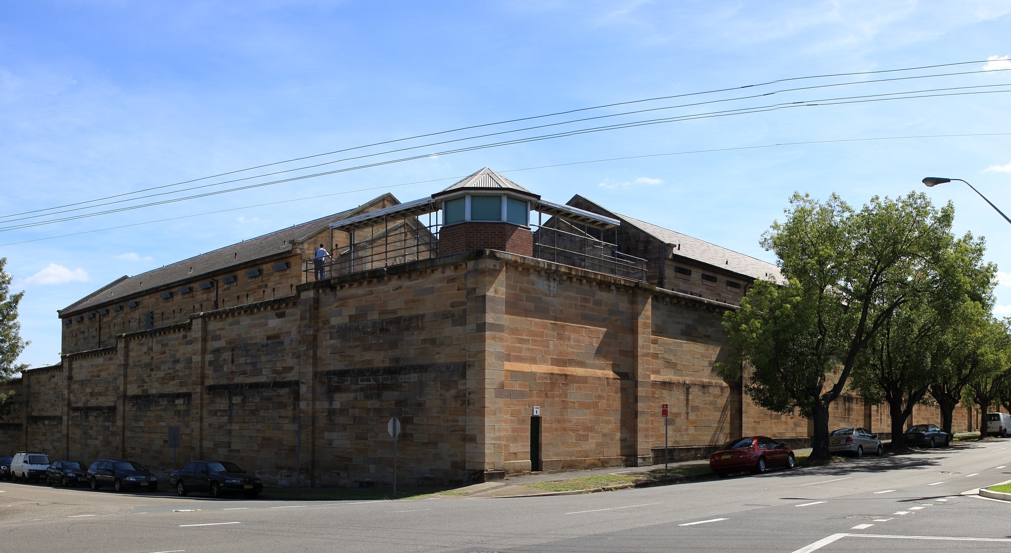
Latitude-33.7987 Longitude151.001 Start Date1842 End Date2011
Description
A gaol was first established at Parramatta in 1798 (designed to hold just eight prisoners), although fire destroyed the initial building the following year. A new facility was built on the same site in 1802. In 1842, a new gaol was built that would remain in use into the twenty-first century. A declining prison population led to the gaol being repurposed as a hospital from 1918 to 1927, when increased demand for prison facilities led to it being refurbished and re-established as a gaol. The Centre closed briefly again between 1997 and 1998, and was shut down permanently in 2011. Today the gaol is a heritage site often used as a filming location, and is regularly opened for tours.
Details
Latitude-42.7472 Longitude146.993 Start Date1937 End Date2012
Description
When the prison first opened in 1937 it consisted of wooden huts to accommodate 20 persons, an orchard, grazing land and a small forest. In subsequent years further buildings were added, and by 1970s the prison farm was a substantial operation consisting of market vegetable gardens, pigs, hens, sheep and a dairy. The prison was closed in 2012 due to the costs of upkeep on the buildings. The property was sold to a private owner in 2015.
Sources
TLCMap IDt982 Linkback
Created At2021-02-17 13:37:20 Updated At2023-12-11 17:48:18
Details
Latitude-34.4877 Longitude150.336 Start Date1979 End Date2014
Description
When Berrimah Prison opened in 1979 to replace the Fannie Bay Gaol, it had an operational capacity for holding 110 inmates. By 2012 this had risen to 750 inmates, but media reports suggested that the facility was overcrowded and in poor hygienic condition. The prison closed in 2014 with the opening of the new Darwin Correctional Centre.
Sources
TLCMap IDt983 Linkback
Created At2021-02-17 13:37:20 Updated At2023-12-11 17:48:18
Details
Latitude-34.8436 Longitude138.628 Start Date1854 End Date2999
Description
Yatala Labour Prison was built to provide accommodations for prisoners whose labour could be used for public works. Initially, 25 prisoners were sent to the Dry Creek site in 1854 to work in the nearby quarries. Prisoners were required to break one cubic yard of rock per day. The prison buildings were repeatedly expanded between the 1850s and 1880s to accommodate larger numbers of prisoners. In the twentieth century prisoners moved from rock breaking into goods production, including boot making, tailoring, tin-smithing, blacksmithing, carpentry and masonry. In 1968 the decision was taken to build a new industries complex on the site, and the provision of educational programmes at the prison expanded across the 1970s. Poor morale among prisoners led to a major prison riot in 1983 that caused significant damage and necessitated major renovations. Today Yatala is a minimum to maximum-security prison for men with capacity to hold up to 458 inmates.
Sources
TLCMap IDt984 Linkback
Created At2021-02-17 13:37:20 Updated At2023-12-11 17:48:18
Details
Latitude-32.5136 Longitude137.813 Start Date1869 End Date2999
Description
Opened in 1869, Port Augusta Prison has continued to operate through to today. Today the low to high-security prison has a capacity for 524 male and 25 female inmates.
Sources
TLCMap IDt985 Linkback
Created At2021-02-17 13:37:20 Updated At2023-12-11 17:48:18
Details
Latitude-31.0736 Longitude150.923 Start Date1881 End Date2999
Description
In 1881, a purpose-built prison opened in Johnston Street, Tamworth to take over the function of the town's earlier gaol, which was regarded as no longer fit for purpose. It received mostly short-sentence prisoners sentenced from the surrounding area. In 1943 the gaol was closed. Five years later, the gaol became the Tamworth Institution for Boys, and was used as a place of secondary punished for boys aged 15 to 18 years who had absconded from or committed offences in other facilities. Conditions at the institution were particularly harsh. In 1976 it became known as Endeavour House, but continued to act as a maximum-security juvenile detention centre for boys convicted of or charged with serious crimes. A spate of suicides at the institution led to its closure in 1990.?In 1991 the facility reopened as an adult prison.?Today Tamworth Correctional Centre is a?medium-security, 89-bed prison for males.
Sources
TLCMap IDt986 Linkback
Created At2021-02-17 13:37:20 Updated At2023-12-11 17:48:18
Details
Latitude-34.7407 Longitude149.74 Start Date1884 End Date2999
Description
Goulburn Gaol?opened?in 1884 with a capacity for?728 inmates. Prison labour was used to build a further 127 cells in 1893. The prison was re-named the Goulburn Reformatory in 1928, and became known as the Goulburn Training Centre in 1949. During this period it had a particular focus on rehabilitating young or first-time offenders through a variety of employment and training programs. In 1992 the centre was again renamed as the Goulburn Correctional Centre. Today the gaol has a capacity for 222 inmates, from those designated minimum-security through to those detained in a SuperMax unit.
Sources
TLCMap IDt987 Linkback
Created At2021-02-17 13:37:20 Updated At2023-12-11 17:48:18
Details
Latitude-33.4178 Longitude149.558 Start Date1888 End Date2999
Description
Overcrowding and poor sanitation led to the construction of a new prison at Bathurst, which opened in 1888 with 308 cells. Up until the First World War, the gaol was mainly designated for receiving prisoners who were repeat offenders or considered unlikely to reform. However, from 1914 it began catering more to prisoners who - though previously convicted - were still considered 'hopeful cases'. During the Second World War the gaol was used as an internment camp for 'enemy aliens'. Its use as a prison resumed after the war. In 1970 the gaol was reclassified as a maximum-security prison. The 1970s saw multiple riots at the prison by inmates dissatisfied with their living conditions: there was no glass in the the windows, no heating in winter but extreme heat in summer, and a piggery operating just outside the gaol produced bad odours and attracted insects. The gaol facilities were criticised during the Nagle Royal Commission into the New South Wales prison system (1976-1978). In 1992, the prison's name was changed to Bathurst Correctional Centre. It remains operational today as a minimum to medium-security prison with capacity for 222 inmates.
Sources
TLCMap IDt988 Linkback
Created At2021-02-17 13:37:20 Updated At2023-12-11 17:48:18
Details
Latitude-31.9606 Longitude141.452 Start Date1892 End Date2999
Description
In 1892 the police lockup at Broken Hill was declared a prison, meaning it went from receiving persons awaiting trial or serving very short sentences, to those sentenced to longer periods of detention. It appears it did not begin to receive such prisoners until the following year, when the remaining inmates at the nearby Silverton Gaol were transferred over to the new 90-bed facility. In 1942 the Broken Hill Gaol was decommissioned as a prison to enable the use of the premises by military forces, but the facility reverted to a prison in 1946. Today it is known as the Broken Hill Correctional Centre, a minimum to medium-security prison for men and women.
Sources
TLCMap IDt989 Linkback
Created At2021-02-17 13:37:20 Updated At2023-12-11 17:48:18
Details
Latitude-29.6767 Longitude152.94 Start Date1893 End Date2999
Description
This was the third gaol to be constructed at Grafton, the first two facilities having proved poorly sited and insufficient to local needs. The prison opened in 1893 to receive medium-security prisoners, but in 1924 was reclassified as a maximum-security prison, before reverting to medium-security status in 1945. From 1942 the gaol was used to house the most intractable prisoners due to a number of serious assaults on officers in the New South Wales prison system. The brutal regime at Grafton that followed was heavily criticised during the 1976-1978 Nagle Royal Commission into the New South Wales prison system. In 1991 Grafton Gaol was converted to a Periodic Detention Centre for minor offenders sentenced to a number of repeated short stays in prison (usually at weekends) rather than a continuous prison term. In 1992 the gaol became the Grafton Correctional Centre. The women's wing of the prison was shut in 2011. Today the prison receives minimum to medium-security male inmates with an operational capacity of 64 prisoners.
Sources
TLCMap IDt98a Linkback
Created At2021-02-17 13:37:20 Updated At2023-12-11 17:48:18
Details
Latitude-19.3504 Longitude146.844 Start Date1898 End Date2999
Description
This is the longest continually operating prison in Queensland. First opened in 1893 as Her Majesty's Penal Establishment Stewart's Creek, today it is known as the Townsville Correctional Centre. It has a diverse prison population of low to high-security male and female inmates, with a maximum operational capacity of 1,178 prisoners.
Sources
TLCMap IDt98b Linkback
Created At2021-02-17 13:37:20 Updated At2023-12-11 17:48:18
Details
Latitude-33.9699 Longitude151.246 Start Date1909 End Date2999
Description
Long Bay was constructed as a replacement for Darlinghurst Gaol. The women's prison opened first in 1909, with the men's prison opening in 1914. The women's prison was vacated in 1970 after the opening of the Silverwater Women's Correctional Centre, and the former Long Bay women's facility was converted to a minimum-security prison for men. In 1975, a supermax prison block was completed at Long Bay, known as Katingal, designed to house terrorists and the most problematic prisoners in the system. The facility became the focus of mostly critical media attention, and was heavily criticised during proceedings of the Nagle Royal Commission into New South Wales prisons, leading to its closure in 1977. Today it is a minimum to maximum-security prison for men with a capacity for 1,200 inmates.
Details
Latitude-33.7381 Longitude150.669 Start Date1914 End Date2999
Description
Emu Plains Prison Farm was established to accommodate male inmates who it was felt could be rehabilitated by workplace training at the prison's working dairy farm. The facility was remodelled to become the Emu Plains Training Centre in 1957, and as the Emu Plains Detention Centre in 1976. In 1994 the male prisoners were transferred to other centres and the property became the Emu Plains Correctional Centre, a minimum-security prison for women. Inmates are employed in the dairy, and programs are in place to permit inmates close contact with their children, who in some circumstances can stay at the prison with their mothers.
Sources
TLCMap IDt98d Linkback
Created At2021-02-17 13:37:20 Updated At2023-12-11 17:48:18
Details
Latitude-34.6371 Longitude117.383 Start Date1927 End Date2999
Description
Pardelup Prison Farm was initially opened in 1927. In 2002 it was downsized into a work camp housing around 12 minimum-security prisoners. Overcrowding in the prison system led to it being reopened as a prison farm with capacity for 85 inmates in 2010. It accommodates minimum-security male prisoners.
Sources
TLCMap IDt98e Linkback
Created At2021-02-17 13:37:20 Updated At2023-12-11 17:48:18
Details
Latitude-29.6342 Longitude152.104 Start Date1928 End Date2999
Description
From 1928 this afforestation camp acted as a site for receiving trusted or low-risk prisoners, who undertook outdoor work and training. It underwent expansions across the 1960s and by the mid 1970s accommodated 95 prisoners. This remains the capacity of the facility,?now known as the Glen Innes Correctional Centre. Today it is classified as a minimum-security prison for men, receiving both sentenced felons and those undergoing a pre-release programme to prepare for re-entry into the community.
Sources
TLCMap IDt98f Linkback
Created At2021-02-17 13:37:20 Updated At2023-12-11 17:48:18
Details
Latitude-35.7997 Longitude147.941 Start Date1930 End Date2999
Description
The Brookfield Afforestation Camp was established at Mannus in 1930 to provide male prisoners with a modified form of prison life that would enable them to acquire skills that could be used on release, such as tree-planting, building maintenance, vegetable growing, dairy farming and pig raising. In 1992 the facility became the Mannus Correctional Centre. Today it is primarily a minimum-security prison for men, although it also acts as a Periodic Detention Centre at weekends for both men and women undergoing periodic detention orders while working on community projects. The facility has accommodations for 164 inmates.
Sources
TLCMap IDt990 Linkback
Created At2021-02-17 13:37:20 Updated At2023-12-11 17:48:18
Details
Latitude-28.326 Longitude152.77 Start Date1934 End Date2999
Description
When this correctional facility was gazetted in 1934, the site was still vacant land. Prisoners lived in tents while working at erecting the prison buildings during the day. Market gardens were also established at the site.?From a capacity of around 50 inmates in 1937, today Palen Creek accommodates around 170 low-security male prisoners. Inmates at the centre work at the various farming industries operating at Palen Creek, as well as a rag industry workshop, where old clothes are prepared and recycled for industrial use.
Sources
TLCMap IDt991 Linkback
Created At2021-02-17 13:37:20 Updated At2023-12-11 17:48:18
Details
Latitude-34.0119 Longitude149.834 Start Date1936 End Date2999
Description
Oberon was one of a number of prison farms and afforestation camps established in the 1930s to give prisoners a chance to learn outdoor work skills. Since 1993 Oberon has been a minimum-security facility for young adult male offenders with a capacity for 100 inmates.
Sources
TLCMap IDt992 Linkback
Created At2021-02-17 13:37:20 Updated At2023-12-11 17:48:18
Details
Latitude-37.4065 Longitude143.488 Start Date1951 End Date2999
Description
Opened as an adult prison in 1951, this facility became a Youth Training Centre for juveniles under sentence in 1965, before again becoming an adult prison in 1993. Today it is a minimum-security male prison with accommodations for over 450 inmates.
Sources
TLCMap IDt993 Linkback
Created At2021-02-17 13:37:20 Updated At2023-12-11 17:48:18
Details
Latitude-36.2331 Longitude149.122 Start Date1957 End Date2999
Description
From 1953, new prison buildings were erected on the Old Cooma Gaol (use of which had discontinued in 1909). The new gaol became known as the Cooma Prison Camp during reconstruction. Cooma Prison opened in 1957 as a medium-security prison, and was renamed the Cooma Correctional Centre in 1992. The Centre closed again in 1998 but reopened again in 2001. Today it is a minimum to medium-security prison for males with a capacity of 160 inmates. A museum dedicated to the prison's history operates next door to the correctional centre, with trusted inmates acting as tour guides.
Sources
TLCMap IDt994 Linkback
Created At2021-02-17 13:37:20 Updated At2023-12-11 17:48:18
Details
Latitude-33.4172 Longitude149.842 Start Date1958 End Date2999
Description
A minimum-security prison for males with a capacity for 260 inmates.
Sources
TLCMap IDt995 Linkback
Created At2021-02-17 13:37:20 Updated At2023-12-11 17:48:18
Details
Latitude-42.8107 Longitude147.341 Start Date1960 End Date2999
Description
A medium to maximum-security prison for men that can hold up to 280 inmates. During a four-month period across 1999 and 2000, five men died while imprisoned at Risdon. This sparked an investigative report by the ABC?Four Corners?program, which showed that there had bee 18 deaths in custody in the prison over the previous 12 years, and that successive governments had been aware of poor conditions at the prison but failed to intercede. A 2001 report by the Tasmanian Ombudsman also criticised the prison as over-crowded and?under-resourced. The facilities were expanded in 2006.
Sources
TLCMap IDt996 Linkback
Created At2021-02-17 13:37:20 Updated At2023-12-11 17:48:18
Details
Latitude-34.0572 Longitude139.758 Start Date1960 End Date2999
Description
A minimum-security, 206-bed correctional facility situated in a rural environment, with prisoners involved in agricultural cultivation and dairy farming.
Sources
TLCMap IDt997 Linkback
Created At2021-02-17 13:37:20 Updated At2023-12-11 17:48:18
Details
Latitude-32.4386 Longitude116.075 Start Date1963 End Date2999
Description
A minimum-security, 326-bed prison for men.
Sources
TLCMap IDt998 Linkback
Created At2021-02-17 13:37:20 Updated At2023-12-11 17:48:18
Details
Latitude-42.8102 Longitude147.343 Start Date1963 End Date2999
Description
A minimum to maximum security prison for women that can hold up to 45 inmates, and also provides accommodation for prisoners' children. It is located adjacent to the Risdon Prison Complex for men.
Sources
TLCMap IDt999 Linkback
Created At2021-02-17 13:37:20 Updated At2023-12-11 17:48:18
Details
Latitude-36.5184 Longitude145.225 Start Date1965 End Date2999
Description
Dhurringile prison was originally a farming homestead built in 1877 in an Italianate style. The house stopped being used to accomodate prisoners in 2007 when new buildings were opened on the site. Today it is a minimum-security prison with capacity for 214 inmates.
Sources
TLCMap IDt99a Linkback
Created At2021-02-17 13:37:20 Updated At2023-12-11 17:48:18
Details
Latitude-35.0465 Longitude117.82 Start Date1966 End Date2999
Description
When it opened in 1966, Albany Prison had a capacity to holding 72 minimum-security inmates. Today it is a minimum to maximum security prison for men with accommodations for up to 310 inmates.
Sources
TLCMap IDt99b Linkback
Created At2021-02-17 13:37:20 Updated At2023-12-11 17:48:18
Details
Latitude-34.7019 Longitude135.8 Start Date1966 End Date2999
Description
A 90-bed, low to medium security prison where sheep and cattle are raised to provide work for inmates.
Sources
TLCMap IDt99c Linkback
Created At2021-02-17 13:37:20 Updated At2023-12-11 17:48:18
Details
Latitude-37.2765 Longitude142.982 Start Date1967 End Date2999
Description
Initially opened as HM Ararat Prison in 1967, this facility replaced the century-old Ballarat Gaol. In 2011 the prison was expanded and renamed the Hopkins Correctional Centre. It is a medium-security prison for men with capacity to hold 382 inmates.
Sources
TLCMap IDt99d Linkback
Created At2021-02-17 13:37:20 Updated At2023-12-11 17:48:18
Details
Latitude-34.8453 Longitude138.642 Start Date1969 End Date2999
Description
A 156-bed, low to high security prison for women. Unlike prisons elsewhere in Australia, this prison does not have facilities for babies to stay with their mothers while they serve their sentence, making South Australia the only state without such such a facility.
Sources
TLCMap IDt99e Linkback
Created At2021-02-17 13:37:20 Updated At2023-12-11 17:48:18
Details
Latitude-33.8308 Longitude151.055 Start Date1970 End Date2999
Description
Silverwater Correctional Centre was established as a women's prison in 1970. The facilities at the site expanded across the 1980s and 1990s, and today it holds both minimum-security male inmates and maximum-security female inmates.
Sources
TLCMap IDt99f Linkback
Created At2021-02-17 13:37:20 Updated At2023-12-11 17:48:18
Details
Latitude-31.862 Longitude115.996 Start Date1971 End Date2999
Description
When it opened in 1971 this correctional facility was called Bandyup Training Centre, and was built to hold 68 women. Over time it has grown to hold up to 259 inmates, and been rechristened Bandyup Women's Prison. From the early 2000s through to 2015 there were reports of significant overcrowding at the prison, which forced women to sleep on mattresses on the floor. The opening of the Melaleuca Remand and Reintegration Facility in 2016 was intended to relieve the pressure on Bandyup.
Sources
TLCMap IDt9a0 Linkback
Created At2021-02-17 13:37:20 Updated At2023-12-11 17:48:18
Details
Latitude-33.3857 Longitude115.669 Start Date1971 End Date2999
Description
A multi-security male prison with a capacity for 384 inmates. Prisoners are required to either work or study while completing their sentence, with the principal source of employment a large market garden that is the primary supplier of all fresh vegetables consumed in the prison system.
Sources
TLCMap IDt9a1 Linkback
Created At2021-02-17 13:37:20 Updated At2023-12-11 17:48:18
Details
Latitude-32.8173 Longitude151.338 Start Date1972 End Date2999
Description
While primarily established as a minimum-security prison for men, in 2012 the facilities were updated to include Australia's first purpose-built maximum-security sex offenders unit.
Sources
TLCMap IDt9a2 Linkback
Created At2021-02-17 13:37:20 Updated At2023-12-11 17:48:18
Details
Latitude-31.8154 Longitude116.338 Start Date1972 End Date2999
Description
A 365-bed, minimum-security male prison, set in a former hospital.?
Sources
TLCMap IDt9a3 Linkback
Created At2021-02-17 13:37:20 Updated At2023-12-11 17:48:18
Details
Latitude-26.9482 Longitude152.75 Start Date1973 End Date2999
Description
A medium to maximum-security male prison with accommodations for up to 988 inmates. In 1997, 120 prisoners in the secure unit?staged melted the lexen walls with toasters and other items to get into the low-security area, where the inmates staged a mass-protest of the prison's new non-smoking policy.
Sources
TLCMap IDt9a4 Linkback
Created At2021-02-17 13:37:20 Updated At2023-12-11 17:48:18
Details
Latitude-41.4331 Longitude147.144 Start Date1976 End Date2999
Description
Located in Cimitiere Street, this maximum security prison receives both male and female inmates under remand while awaiting trial.
Sources
TLCMap IDt9a5 Linkback
Created At2021-02-17 13:37:20 Updated At2023-12-11 17:48:18
Details
Latitude-32.1032 Longitude115.92 Start Date1982 End Date2999
Description
A minimum to maximum-security prison for men, with capacity for up to 1,225 inmates.
Sources
TLCMap IDt9a6 Linkback
Created At2021-02-17 13:37:20 Updated At2023-12-11 17:48:18
Details
Latitude-33.7233 Longitude150.915 Start Date1983 End Date2999
Description
A minimum to maximum-security male prison with a capacity for up to 823 inmates. Serious riots occurred there in 1987 and 1990. In 2009 it was handed over to private management by the GEO Group.
Sources
TLCMap IDt9a7 Linkback
Created At2021-02-17 13:37:20 Updated At2023-12-11 17:48:18
Details
Latitude-28.8356 Longitude114.701 Start Date1984 End Date2999
Description
A 323-bed, minimum to medium-security prison for men and women, as well as maximum-security prisoners awaiting trial. In 2010 a report on conditions at the prison found that the facility was overcrowded, with up to three inmates forced to share cells that were designed to hold only one.
Sources
TLCMap IDt9a8 Linkback
Created At2021-02-17 13:37:20 Updated At2023-12-11 17:48:18
Details
Latitude-20.7212 Longitude117.133 Start Date1984 End Date2999
Description
A minimum to medium-security?prison for men and women, although it also has capacity to accommodate short-term maximum-security prisoners. It can house up to 161 inmates.
Sources
TLCMap IDt9a9 Linkback
Created At2021-02-17 13:37:20 Updated At2023-12-11 17:48:18
Details
Latitude-34.9244 Longitude138.59 Start Date1986 End Date2999
Description
A maximum-security, 267-bed male prison used to hold inmates awaiting trial.
Sources
TLCMap IDt9aa Linkback
Created At2021-02-17 13:37:20 Updated At2023-12-11 17:48:18
Details
Latitude-35.1137 Longitude139.233 Start Date1987 End Date2999
Description
A low to medium-security male prison with capacity to hold 472 inmates.
Sources
TLCMap IDt9ab Linkback
Created At2021-02-17 13:37:20 Updated At2023-12-11 17:48:18
Details
Latitude-36.9777 Longitude144.048 Start Date1988 End Date2999
Description
A 54-bed, minimum-security women's prison that focuses on preparing women for release by providing programs and employment opportunities.
Sources
TLCMap IDt9ac Linkback
Created At2021-02-17 13:37:20 Updated At2023-12-11 17:48:18
Details
Latitude-27.5823 Longitude152.921 Start Date1988 End Date2999
Description
In 1988, this prison opened as the Sir David Longland Correctional Centre. It was renovated and re-opened as the Brisbane Correctional Centre in 2008. It is a maximum-security facility with accommodations for 558 prisoner, including a special unit specifically designed for 17-year-old prisoners.
Sources
TLCMap IDt9ad Linkback
Created At2021-02-17 13:37:20 Updated At2023-12-11 17:48:18
Details
Latitude-33.9672 Longitude150.957 Start Date1989 End Date2999
Description
A prison facility at Holsworthy Barracks authorised to hold members of the Australian Army, Royal Australian Navy and Royal Australian Air Force who have been sentenced to more than 14 days' detention, as well as service personnel on remand awaiting trial.
Sources
TLCMap IDt9ae Linkback
Created At2021-02-17 13:37:20 Updated At2023-12-11 17:48:18
Details
Latitude-37.8126 Longitude144.951 Start Date1989 End Date2999
Description
Originally built to accommodate Melbourne's remand prisoners, the primary purpose of this facility today is to provide statewide assessment and orientation services for all male prisoners received into the Victorian prison system.
Sources
TLCMap IDt9af Linkback
Created At2021-02-17 13:37:20 Updated At2023-12-11 17:48:18
Details
Latitude-27.5496 Longitude152.674 Start Date1989 End Date2999
Description
When it first opened in 1990, Borallon Correctional Centre was the first privately-operated correctional facility in Australia. It was classed as high-security with a capacity for 492 inmates. It was decommissioned in 2012 due to the opening of the new Southern Queensland Correctional Centre. It reopened in 2016 as the Borallon Training and Correctional Centre as Queensland first dedicated training prison, focused on educational and employment outcomes for prisoners.
Sources
TLCMap IDt9b0 Linkback
Created At2021-02-17 13:37:20 Updated At2023-12-11 17:48:18
Details
Latitude-17.1124 Longitude145.361 Start Date1989 End Date2999
Description
The centre has a total capacity for 498 inmates catering to all security levels, including 115 'open security' inmates who work on the prison farm. It is a male-only facility.
Sources
TLCMap IDt9b1 Linkback
Created At2021-02-17 13:37:20 Updated At2023-12-11 17:48:18
Details
Latitude-32.2201 Longitude150.923 Start Date1989 End Date2999
Description
A minimum-security, 256-bed prison for males. Prior to its conversion to a correctional centre, the property was used as a child welfare institution from 1945 to 1986.
Sources
TLCMap IDt9b2 Linkback
Created At2021-02-17 13:37:20 Updated At2023-12-11 17:48:18
Details
Latitude-37.9844 Longitude144.353 Start Date1990 End Date2999
Description
A maximum-security, 448-bed prison for men. Over the last? decade it has been the scenes of several high-profile incidents of violence, both between inmates and by inmates on guards.
Sources
TLCMap IDt9b3 Linkback
Created At2021-02-17 13:37:20 Updated At2023-12-11 17:48:18
Details
Latitude-37.0806 Longitude144.239 Start Date1990 End Date2999
Description
A medium-security, 409-bed prison.
Sources
TLCMap IDt9b4 Linkback
Created At2021-02-17 13:37:20 Updated At2023-12-11 17:48:18
Details
Latitude-33.4298 Longitude150.119 Start Date1990 End Date2999
Description
A maximum-security prison for men.?
Sources
TLCMap IDt9b5 Linkback
Created At2021-02-17 13:37:20 Updated At2023-12-11 17:48:18
Details
Latitude-33.6499 Longitude150.783 Start Date1991 End Date2999
Description
A minimum-security, 200-bed prison for male inmates. It is named for former Comptroller General of the New South Wales Department of Corrective Services John Morony.
Sources
TLCMap IDt9b6 Linkback
Created At2021-02-17 13:37:20 Updated At2023-12-11 17:48:18
Details
Latitude-32.2415 Longitude115.879 Start Date1991 End Date2999
Description
A minimum to maximum-security prison for men with capacity for 680 inmates.
Sources
TLCMap IDt9b7 Linkback
Created At2021-02-17 13:37:20 Updated At2023-12-11 17:48:18
Details
Latitude-27.5791 Longitude152.934 Start Date1992 End Date2999
Description
A high-security, 890-bed prison for males, privately managed by the GEO Group. The facility is named in honour of?Arthur Gorrie, a Brisbane small businessman who volunteered for many years in work to help rehabilitate prison inmates.
Sources
TLCMap IDt9b8 Linkback
Created At2021-02-17 13:37:20 Updated At2023-12-11 17:48:18
Details
Latitude-34.862 Longitude147.56 Start Date1993 End Date2999
Description
A minimum to medium security prison for males, with accommodations for up to 790 inmates. It is privately managed by the GEO Group.
Sources
TLCMap IDt9b9 Linkback
Created At2021-02-17 13:37:20 Updated At2023-12-11 17:48:18
Details
Latitude-37.8575 Longitude140.685 Start Date1995 End Date2999
Description
A low to medium-security prison for males, although it also has accommodations for short-term, high-security male and female prisoners as required. It is privately managed by G4S.
Sources
TLCMap IDt9ba Linkback
Created At2021-02-17 13:37:20 Updated At2023-12-11 17:48:18
Details
Latitude-37.7805 Longitude144.743 Start Date1996 End Date2999
Description
A maximum-security, 520-bed women's prison. In 2003 a male prison guard was charged with raping a mentally ill inmate at the facility after DNA tests revealed he was the father of a child conceived after she was committed to the prison. Now known as the Dame Phyllis Frost Centre.
Sources
TLCMap IDt9bb Linkback
Created At2021-02-17 13:37:20 Updated At2023-12-11 17:48:18
Details
Latitude-23.8585 Longitude133.801 Start Date1996 End Date2999
Description
A medium to maximum-security, 400-bed prison. The centre runs an active art program that enables inmates to develop art and business skills, with all proceeds from sales going to support victims of crime or prison programs.
Sources
TLCMap IDt9bc Linkback
Created At2021-02-17 13:37:20 Updated At2023-12-11 17:48:18
Details
Latitude-37.8287 Longitude144.752 Start Date1997 End Date2999
Description
A maximum-security male prison with capacity for up to 1,087 inmates. It is privately managed by G4S Australia.
Sources
TLCMap IDt9bd Linkback
Created At2021-02-17 13:37:20 Updated At2023-12-11 17:48:18
Details
Latitude-38.1079 Longitude146.97 Start Date1997 End Date2999
Description
A medium-security, 800-bed prison privately managed by the GEO Group.
Sources
TLCMap IDt9be Linkback
Created At2021-02-17 13:37:20 Updated At2023-12-11 17:48:18
Details
Latitude-33.8307 Longitude151.055 Start Date1997 End Date2999
Description
A maximum-security, 900-bed prison for males awaiting trial or sentence. In 1999, armed robber John Killick escaped from the facility via helicopter, remaining on the run with his accomplice Lucy Dudko for six weeks until they were apprehended.
Sources
TLCMap IDt9bf Linkback
Created At2021-02-17 13:37:20 Updated At2023-12-11 17:48:18
Details
Latitude-28.1633 Longitude153.212 Start Date1997 End Date2999
Description
This centre houses 104 male prisoners and has an annex with housing for 25 female prisoners, a mix of short and long-term.
Sources
TLCMap IDt9c0 Linkback
Created At2021-02-17 13:37:20 Updated At2023-12-11 17:48:18
Details
Latitude-42.8793 Longitude147.329 Start Date1999 End Date2999
Description
An maximum-security, 50-bed prison for male and female inmates remanded for trial.
Sources
TLCMap IDt9c1 Linkback
Created At2021-02-17 13:37:20 Updated At2023-12-11 17:48:18
Details
Latitude-27.5839 Longitude152.907 Start Date1999 End Date2999
Description
A female prison with capacity to hold 270 inmates.
Sources
TLCMap IDt9c2 Linkback
Created At2021-02-17 13:37:20 Updated At2023-12-11 17:48:18
Details
Latitude-27.5835 Longitude152.904 Start Date1999 End Date2999
Description
A high-security prison with accommodations for 600 inmates.
Sources
TLCMap IDt9c3 Linkback
Created At2021-02-17 13:37:20 Updated At2023-12-11 17:48:18
Details
Latitude-30.5322 Longitude146.875 Start Date2000 End Date2999
Description
A minimum-security, 70-bed prison for Aboriginal males, mostly first-time offenders aged 18 to 25.?Yetta Dhinnakkal?is an indigenous phrase meaning 'the right path'. The facility - previously a cattle station - is an outdoor prison without walls or fences where inmates are guided by tribal elders, and undertake vocational training.
Sources
TLCMap IDt9c4 Linkback
Created At2021-02-17 13:37:20 Updated At2023-12-11 17:48:18
Details
Latitude-32.9141 Longitude144.311 Start Date2000 End Date2999
Description
A minimum-security prison for men with an operational capacity for 55 inmates.
Sources
TLCMap IDt9c5 Linkback
Created At2021-02-17 13:37:20 Updated At2023-12-11 17:48:18
Details
Latitude-31.8333 Longitude116.342 Start Date2001 End Date2999
Description
A medium-security prison for men with operational capacity for 1,433 inmates. It has been privately managed by Serco Australia since 2006.
Sources
TLCMap IDt9c6 Linkback
Created At2021-02-17 13:37:20 Updated At2023-12-11 17:48:18
Details
Latitude-23.2267 Longitude150.47 Start Date2001 End Date2999
Description
A low to high-security facility that can hold up to 500 inmates, and as at 2018 is under expansion.
Sources
TLCMap IDt9c7 Linkback
Created At2021-02-17 13:37:20 Updated At2023-12-11 17:48:18
Details
Latitude-25.4782 Longitude152.649 Start Date2003 End Date2999
Description
A medium to maximum-security prison for men with a capacity to hold up to 500 inmates.
Sources
TLCMap IDt9c8 Linkback
Created At2021-02-17 13:37:20 Updated At2023-12-11 17:48:18
Details
Latitude-33.6491 Longitude150.782 Start Date2004 End Date2999
Description
A medium-security, 260-bed facility for female prisoners. There is a wildlife centre behind the gaol where some of the inmates work.
Sources
TLCMap IDt9c9 Linkback
Created At2021-02-17 13:37:20 Updated At2023-12-11 17:48:18
Details
Latitude-31.0686 Longitude152.753 Start Date2004 End Date2999
Description
A minimum to medium-security prison for males and females with capacity for housing 500 inmates.
Sources
TLCMap IDt9ca Linkback
Created At2021-02-17 13:37:20 Updated At2023-12-11 17:48:18
Details
Latitude-32.002 Longitude115.897 Start Date2004 End Date2999
Description
A minimum-security, 95-bed facility for female prisoners preparing for reintegration into the community.
Sources
TLCMap IDt9cb Linkback
Created At2021-02-17 13:37:20 Updated At2023-12-11 17:48:18
Details
Latitude-36.3488 Longitude146.654 Start Date2005 End Date2999
Description
A minimum-security prison with accommodation for 120 inmates.
Sources
TLCMap IDt9cc Linkback
Created At2021-02-17 13:37:20 Updated At2023-12-11 17:48:18
Details
Latitude-37.9772 Longitude144.35 Start Date2006 End Date2999
Description
A 394-bed, medium-security facility that offers a variety of rehabilitation and educational programs to inmates.
Sources
TLCMap IDt9cd Linkback
Created At2021-02-17 13:37:20 Updated At2023-12-11 17:48:18
Details
Latitude-37.7922 Longitude144.746 Start Date2006 End Date2999
Description
A maximum-security facility for inmates awaiting trial under remand. It has accommodation for 805 prisoners.
Sources
TLCMap IDt9ce Linkback
Created At2021-02-17 13:37:20 Updated At2023-12-11 17:48:18
Details
Latitude-32.5048 Longitude148.982 Start Date2007 End Date2999
Description
A maximum-security prison for males and females, both those under sentence and awaiting trial. It has capacity for 750 inmates.
Sources
TLCMap IDt9cf Linkback
Created At2021-02-17 13:37:20 Updated At2023-12-11 17:48:18
Details
Latitude-35.3689 Longitude149.17 Start Date2008 End Date2999
Description
A minimum to maximum-security prison and remand centre for male and female inmates, with a capacity for 300 prisoners. It is the first prison in Australia that was purpose built to meet international human rights obligations. The centre is named in honour of nineteenth-century penal reformer?Alexander Maconochie, who worked in the penal colonies at Van Diemen's Land and Norfolk Island.?
Sources
TLCMap IDt9d0 Linkback
Created At2021-02-17 13:37:20 Updated At2023-12-11 17:48:18
Details
Latitude-34.9201 Longitude150.598 Start Date2010 End Date2999
Description
A prison with accommodations for 600 prisoners, both those under sentence and on remand.
Sources
TLCMap IDt9d1 Linkback
Created At2021-02-17 13:37:20 Updated At2023-12-11 17:48:18
Details
Latitude-32.0746 Longitude115.844 Start Date2012 End Date2999
Description
A minimum-security prison designed for 18-28 year-old men preparing to transition back into the community. It was privately managed by Serco Australia before returning to public hands in 2018.
Sources
TLCMap IDt9d2 Linkback
Created At2021-02-17 13:37:20 Updated At2023-12-11 17:48:18
Details
Latitude-17.3531 Longitude123.679 Start Date2012 End Date2999
Description
A minimum to medium-security prison with accommodations for 120 male and 30 female prisoners. This architecture award-winning facility consists of 42 buildings, and is specifically designed to meet the needs of and provide programs for Aboriginal prisoners.
Sources
TLCMap IDt9d3 Linkback
Created At2021-02-17 13:37:20 Updated At2023-12-11 17:48:18
Details
Latitude-27.4708 Longitude152.303 Start Date2012 End Date2999
Description
A minimum to maximum-security facility with a 300-bed capacity for male prisoners, privately managed by Serco. The prison includes accommodation for aged and infirm prisoners, and those receiving palliative care.
Sources
TLCMap IDt9d4 Linkback
Created At2021-02-17 13:37:21 Updated At2023-12-11 17:48:18
Details
Latitude-12.4463 Longitude131.031 Start Date2014 End Date2999
Description
A minimum to maximum-security prison with a capacity to house up to 1,048 prisoners.
Sources
TLCMap IDt9d5 Linkback
Created At2021-02-17 13:37:21 Updated At2023-12-11 17:48:18
Details
Latitude-30.7906 Longitude121.479 Start Date2016 End Date2999
Description
A medium-security facility for both male and female prisoners, it also has the capacity to manage maximum security prisoners when required. Its total capacity is 367 prisoners.
Sources
TLCMap IDt9d6 Linkback
Created At2021-02-17 13:37:21 Updated At2023-12-11 17:48:18
Details
Latitude-32.1042 Longitude115.921 Start Date2016 End Date2999
Description
A privately-managed, maximum-security prison with accommodations for 254 female prisoners.
Sources
TLCMap IDt9d7 Linkback
Created At2021-02-17 13:37:21 Updated At2023-12-11 17:48:18
Details
Latitude-37.7848 Longitude144.746 Start Date2017 End Date2999
Description
A medium-security prison for male prisoners, both those under sentence and awaiting trial. Described as Victoria's 'most technically advanced prison', it has accommodations for up to 1,000 prisoners, including 75 dedicated forensic mental health beds for prisoners with a mental illness.
Sources
TLCMap IDt9d8 Linkback
Created At2021-02-17 13:37:21 Updated At2023-12-11 17:48:19
Details
Latitude-34.462 Longitude150.847 Start Date2017 End Date2999
Description
The Illawarra Reintegration has accommodation for 60 minimum security offenders.
Sources
TLCMap IDt9d9 Linkback
Created At2021-02-17 13:37:21 Updated At2023-12-11 17:48:19