Gazetteer of Historical Australian Places
Layer
| Name | Virtual Sourcebook for Aboriginal Studies in the Hunter Region Guide: 1820-1829 |
|---|---|
| Description | This site was originally created to assist the Awaba project, a collaborative venture by the University of Newcastle's School of Liberal Arts and the Wollotuka School of Aboriginal Studies. The original brief was to digitise the works of Reverend Lancelot Threlkeld, but we continued to identify materials from the collections relating to Aboriginal people throughout Newcastle and the wider Hunter Region. Due to the assistance of scholars and members of the local indigenous and non indigenous community the site grew rapidly to include many hundreds of sources. We hope that this will lead to a better understanding and respect of the richness and beauty of the Aboriginal view. |
| Type | Other |
| Content Warning | |
| Contributor | Shellie Smith |
| Entries | 13 |
| Allow ANPS? | No |
| Added to System | 2024-04-30 10:31:59 |
| Updated in System | 2024-05-08 12:03:41 |
| Subject | |
|---|---|
| Creator | |
| Publisher | |
| Contact | |
| Citation | |
| DOI | |
| Source URL | |
| Linkback | |
| Date From | |
| Date To | |
| Image |
| Latitude From | |
|---|---|
| Longitude From | |
| Latitude To | |
| Longitude To | |
| Language | |
| License | |
| Usage Rights | |
| Date Created (externally) |
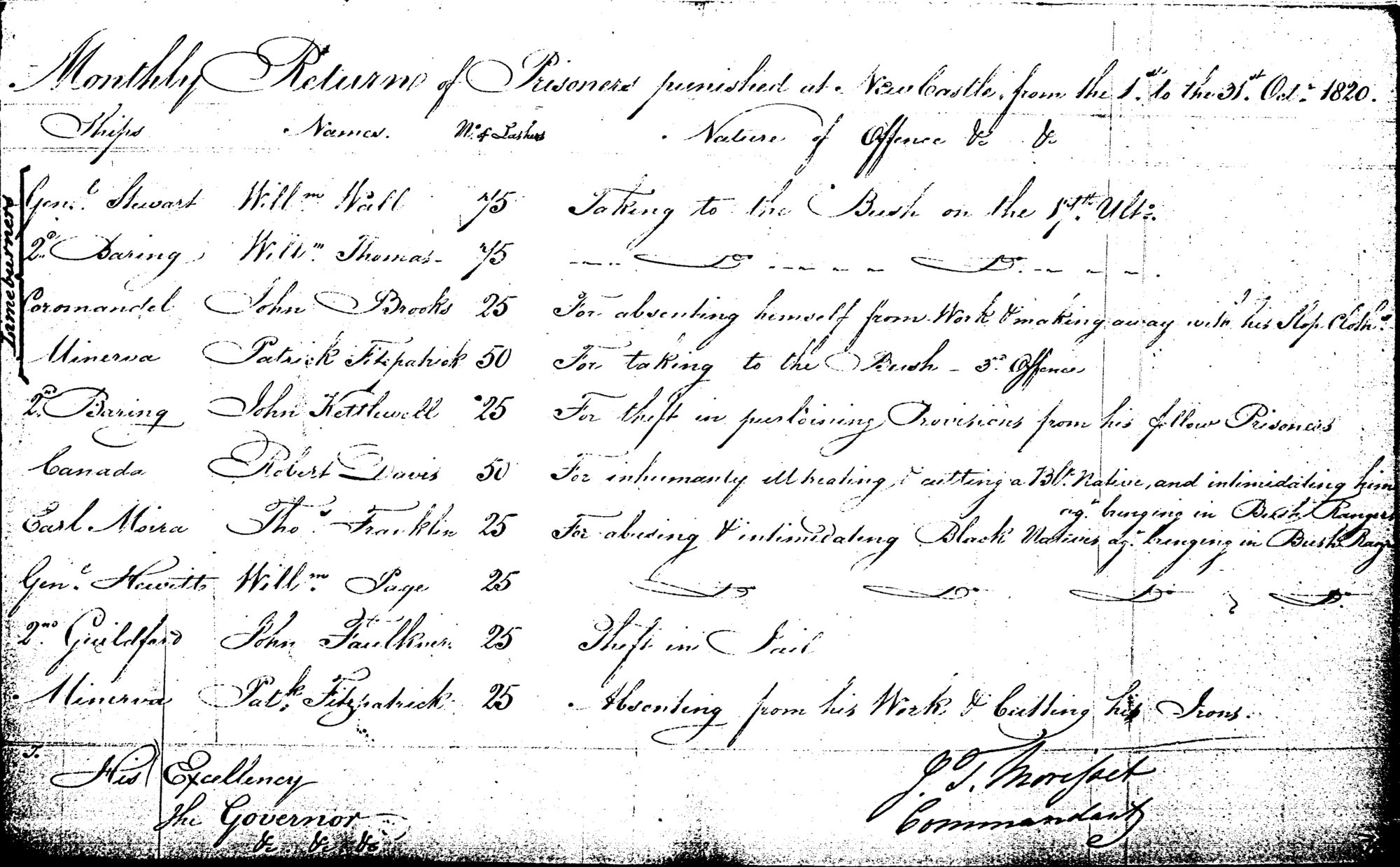
Monthly Returns of Punishments, Newcastle, 31st October 1820
- Placename
- Newcastle
- Type
- Other
Details
Description
Description
Monthly Returns of Punishments - Convicts
SubjectConvictsAboriginal AustraliansCreatorMorisset, James, 1782-1852TitleMonthly Returns of Punishments, Newcastle, CSIL Special Bundles 4/1718. (Oct 1820): 115. Includes convicts punished for harming Aborigines.CollectionVirtual Sourcebook for Aboriginal Studies in the Hunter RegionDate Created31st October 1820Identifiercsiloct1820
Sources
https://livinghistories.newcastle.edu.au/nodes/view/57449
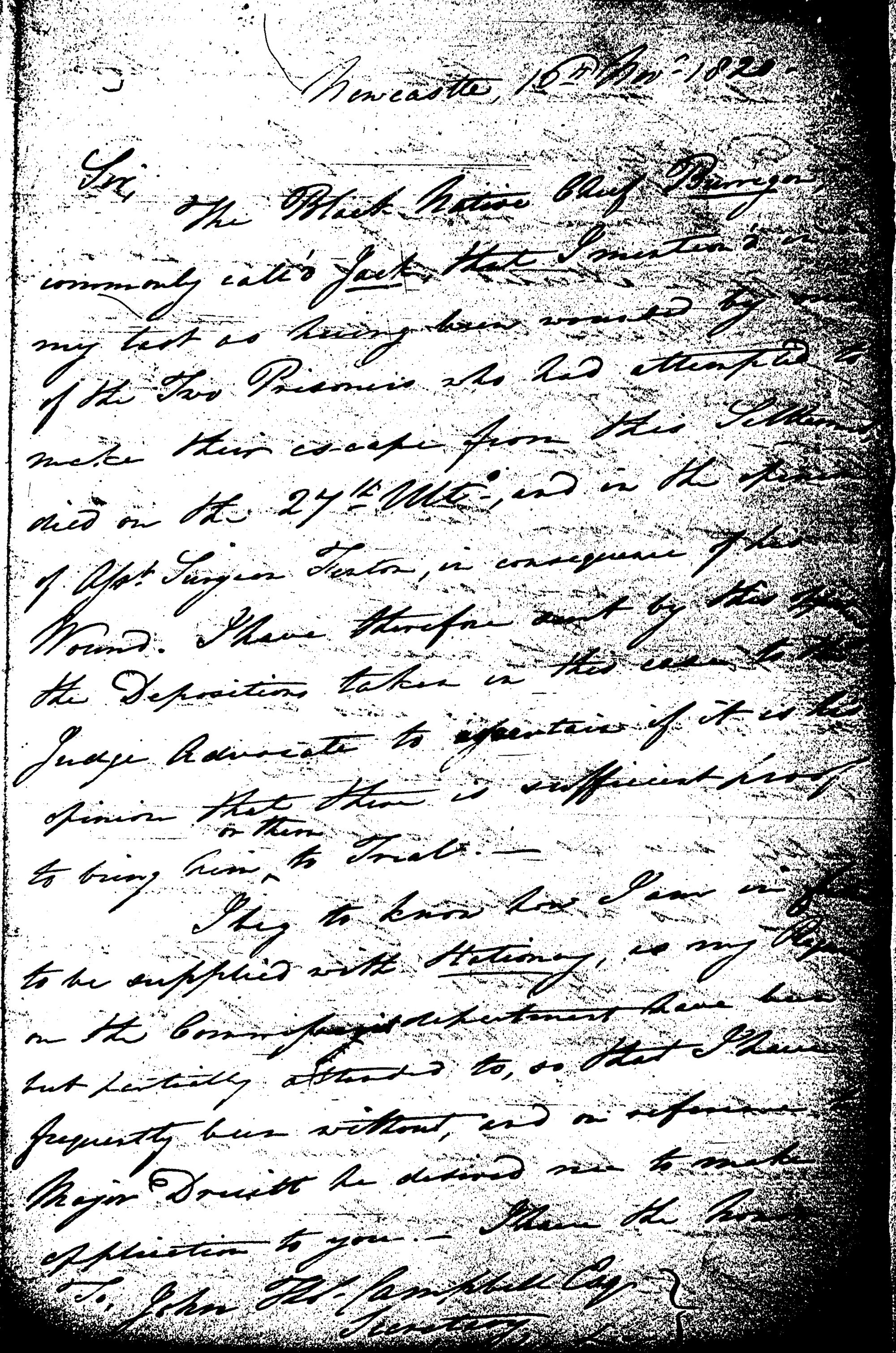
Morisset to Campbell. (31st October 1820): 135-137
- Placename
- Newcastle
- Type
- Other
Details
Description
Description
Convicts John Kirby and James Thompson, and the wounding of Jack, Chief of the Newcastle Tribe.
SubjectKirby, JohnAboriginal AustraliansBurriganThompson, JamesCreatorMorisset, James, 1782-1852TitleMorisset to Campbell. CSIL 4/1807 (31st Oct 1820): 135-137. Respecting the convicts John Kirby and James Thompson, and the wounding of Jack, Chief of the Newcastle Tribe.CollectionVirtual Sourcebook for Aboriginal Studies in the Hunter RegionDate Created31st October 1820Identifiercsiloct1820b
Sources
https://livinghistories.newcastle.edu.au/nodes/view/57450
Morisset to Campbell. (16th Nov 1820): 143. Respecting the the death of King Burrigan
- Placename
- Newcastle
- Type
- Other
Details
Description
Description
Death of King Burrigan (aka Jack, Chief of the Newcastle Tribe).
SubjectAboriginal AustraliansBurriganCreatorMorisset, James, 1782-1852TitleMorisset to Campbell. CSIL 4/1807 (16th Nov 1820): 143. Respecting the the death of King Burrigan (aka Jack, Chief of the Newcastle Tribe).CollectionVirtual Sourcebook for Aboriginal Studies in the Hunter RegionDate Created16th November 1820Identifiercsilnov1820
Sources
https://livinghistories.newcastle.edu.au/nodes/view/57448
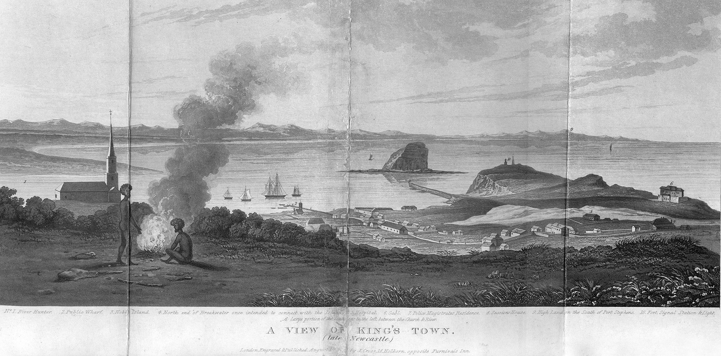
A View of King's Town (Late Newcastle
- Placename
- Newcastle
- Type
- Other
Details
Description
itle: A View of King's Town (Late Newcastle).
Date: 1828
Engraver: Joseph Cross
Published in:
Author: Dangar, H. (Henry), 1796-1861
Title: Index and directory to map of the country bordering upon the River Hunter ; the lands of the Australian-Agricultural Company, with the ground plan and allotments of King's Town, New South Wales : containing a detail of the annual quit rent and amount of the redemption of the same ; also historical notes upon the tenure and principle of granting lands in the colony since 1810 ; also for the guidance of emigrant settlers, a description of the unlocated country in the vicinity of Hunter's River ; useful geographical notes on Liverpool Plains ; the present regulations and conditions upon which grants and sales of land are made by government, with observations thereon, with a view of the present state of agriculture in the colony, price of land, advice to settlers, & c. the whole forming with regard to land affairs in that colony, a complete emigrant's guide / by H. Dangar
Published: London : Joseph Cross, 1828
Sources
https://libguides.newcastle.edu.au/aboriginalsourcebook/kingstown1
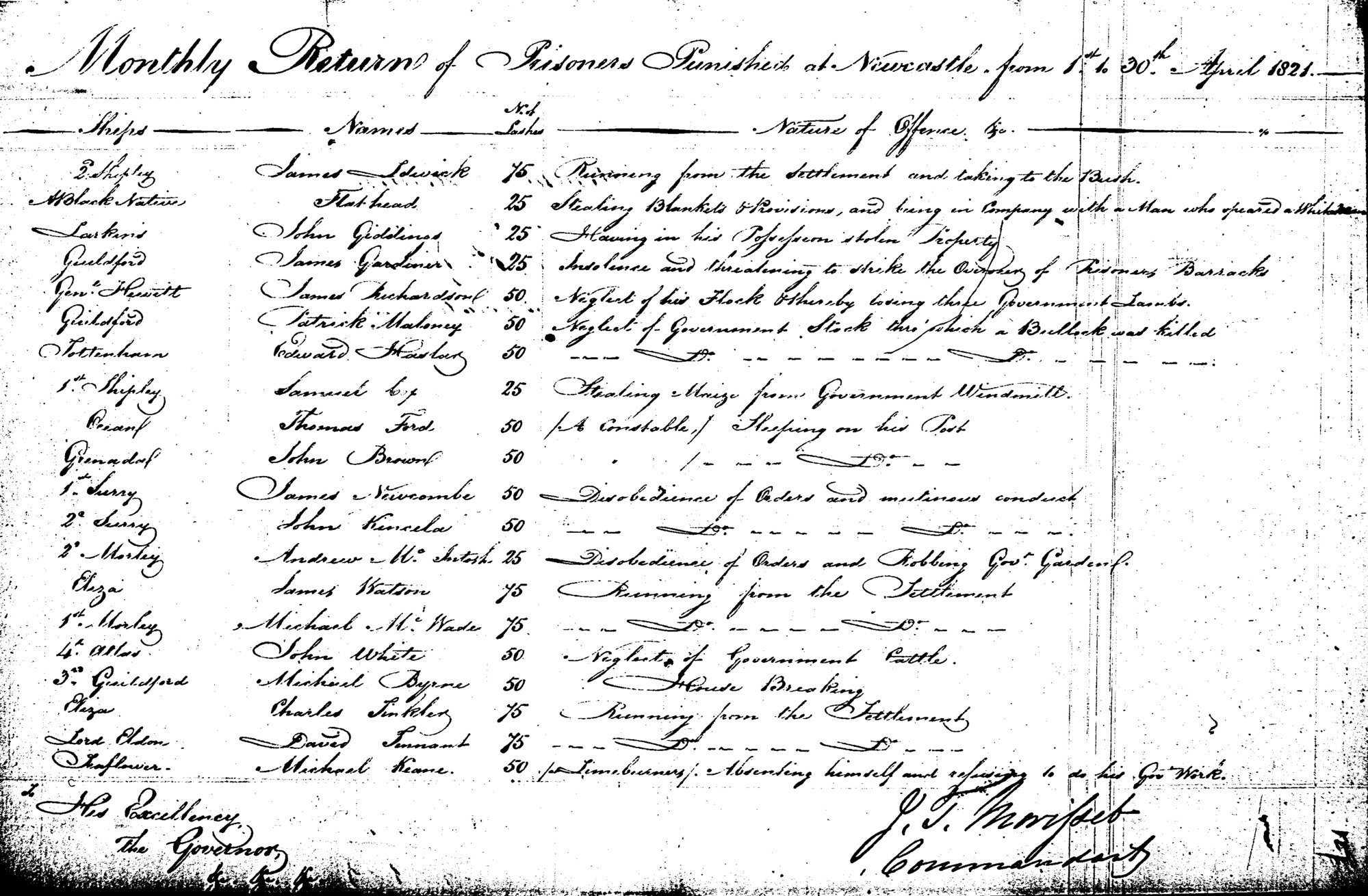
Monthly Returns of Punishments, Newcastle, 30 April 1821
- Placename
- Newcastle
- Type
- Other
Details
Description
Description
Aboriginal man known as Flathead
SubjectAboriginal AustraliansNewcastle (N.S.W.)ConvictsCreatorMorisset, James, 1782-1852TitleMonthly Returns of Punishments, Newcastle, CSIL Special Bundles 4/1718. (Apr 1821): 127. Reference to Aboriginal man known as Flathead.CollectionVirtual Sourcebook for Aboriginal Studies in the Hunter RegionDate Created30th April 1821Identifiercsilaug1821
Sources
https://livinghistories.newcastle.edu.au/nodes/view/57444
Transcript of Lachlan Macquarie: A Voyage – and Tour of Inspection – from Port Jackson – to the Settlements of Port Macquarie, and Newcastle: – In November 1821.
- Placename
- Port Macquarie / Newcastle
- Type
- Other
Details
Description
- Transcript of Lachlan Macquarie: A Voyage – and Tour of Inspection – from Port Jackson – to the Settlements of Port Macquarie, and Newcastle: – In November 1821. [Macquarie University have created transcriptions of the Journals of Elizabeth and Lachlan Macquarie through the magnificent project entitled Journeys in Time 1809 - 1822.] Mentions meeting with Bungaree, Chief of the Boan Native Tribe, with all his own Family, and 30 more of his Tribe at Wallis' Plains.
Sources
Morisset to Goulburn. 28th July 1822 Colonial Secretary: Letters Received, 1822
- Placename
- Newcastle
- Type
- Other
Details
Description
Description
Settlement further up the Hunter River and the need to protect settlers from Aborigines and bushrangers.
SubjectAboriginal AustraliansCreatorMorisset, James, 1782-1852TitleMorisset to Goulburn. 28th July 1822 Colonial Secretary: Letters Received, 1822. SRNSW 4/1808. Concerning the settlement further up the Hunter River and the need to protect settlers from Aborigines and bushrangers.CollectionVirtual Sourcebook for Aboriginal Studies in the Hunter RegionDate Created28th July 1822Identifiermorisset1822
Sources
https://livinghistories.newcastle.edu.au/nodes/view/57610
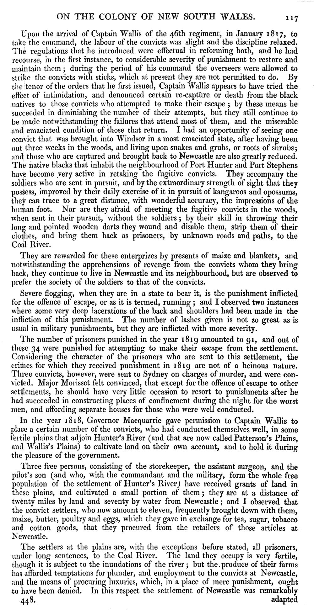
Blacktracking and how Aborigines show considerable skill in tracking escaped convicts
- Placename
- Newcastle
- Type
- Other
Details
Description
SubjectAboriginal AustraliansCreatorBigge, John Thomas, 1780-1843TitleExcerpt relating to blacktracking and how Aborigines show considerable skill in tracking escaped convicts from Report of the Commissioner of Inquiry into the State of the Colony of New South Wales, 19th June 1822. 1:117CollectionVirtual Sourcebook for Aboriginal Studies in the Hunter RegionIdentifierbigge1822
Sources
https://livinghistories.newcastle.edu.au/nodes/view/57394
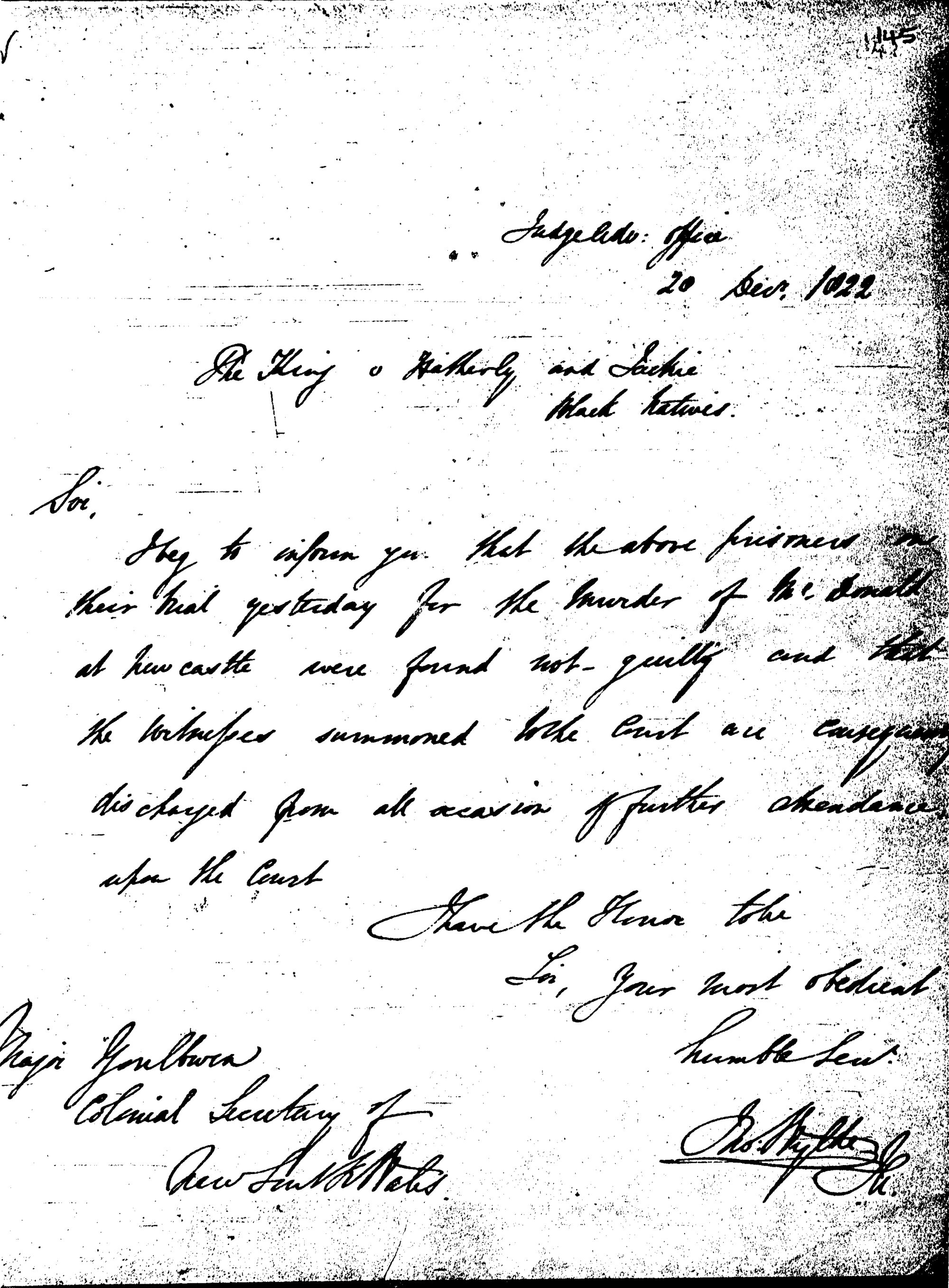
Wylde to Goulburn. (20th December 1822): 145. Regarding Aborigines tried for murder
- Placename
- Newcastle
- Type
- Other
Details
Description
Description
Aborigines tried for the murder of MacDonald at Newcastle.
SubjectAboriginal AustraliansCreatorWylde, J.T.TitleWylde to Goulburn. CSIL 4/1758 (20th Dec 1822): 145. Regarding Aborigines tried for the murder of MacDonald at Newcastle.CollectionVirtual Sourcebook for Aboriginal Studies in the Hunter RegionDate Created20th December 1822Identifierwylde1822a
Sources
https://livinghistories.newcastle.edu.au/nodes/view/57927
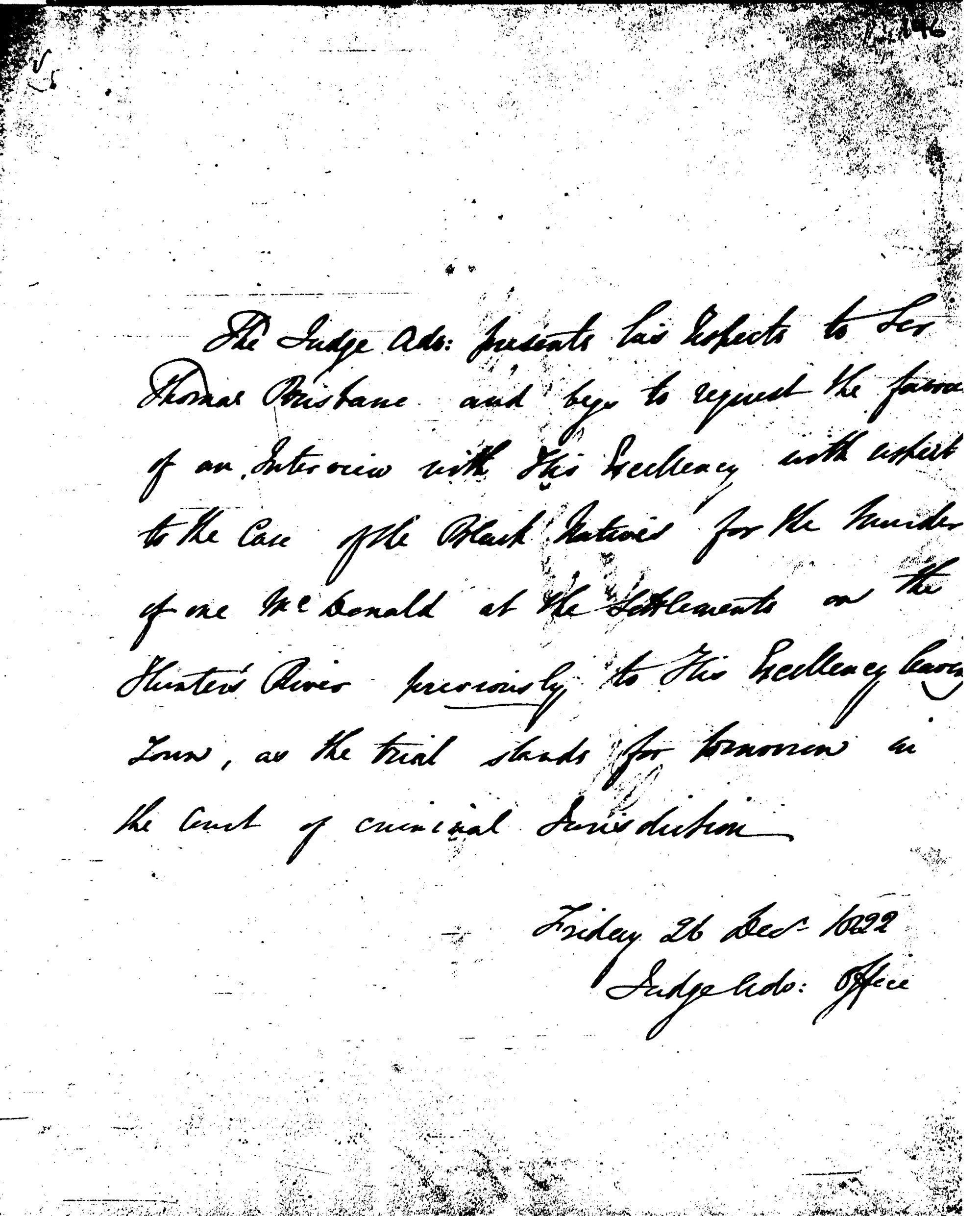
Wylde to Brisbane. (26th Dec 1822): 146. Regarding Aborigines tried for murder
- Placename
- Newcastle
- Type
- Other
Details
Description
Description
Aborigines tried for the murder of MacDonald at Newcastle.
SubjectAboriginal AustraliansNewcastle (N.S.W.)CreatorWylde, J.T.TitleWylde to Brisbane. CSIL 4/1758 (26th Dec 1822): 146. Regarding Aborigines tried for the murder of MacDonald at Newcastle.CollectionVirtual Sourcebook for Aboriginal Studies in the Hunter RegionDate Created26th December 1822Identifierwylde1822b
Sources
https://livinghistories.newcastle.edu.au/nodes/view/57928
Details
Description
- R. v. Fitzpatrick and Colville. Supreme Court of New South Wales. Forbes C.J., 21 June 1824. Source: Sydney Gazette, 24 June 1824. Bulwaddy, a black native, was present at some part of the transactions and provided some testimony to the events.[Decisions of the Superior Courts of New South Wales, 1788-1899. Published by the Division of Law Macquarie University]
Sources
Platt to Goulburn, 11th Dec 1824.
- Placename
- Hunter River / Mayfield
- Type
- Other
Details
Description
SubjectAboriginal AustraliansHunter River (N.S.W.)CreatorPlatt, John Laurio, 1782-1836TitlePlatt to Goulburn. CSIL 4/1811 (11th Dec 1824): 199. Mention of crops of maize swept off by the Blacks and the "severe" example made of them at Ironbark Hill, Hunters River. (Steel River site formerly the Murray Dwyer Orphanage, Mayfield).CollectionVirtual Sourcebook for Aboriginal Studies in the Hunter RegionDate Created11th December 1824Identifiercsildec1824
Sources
https://livinghistories.newcastle.edu.au/nodes/view/57445
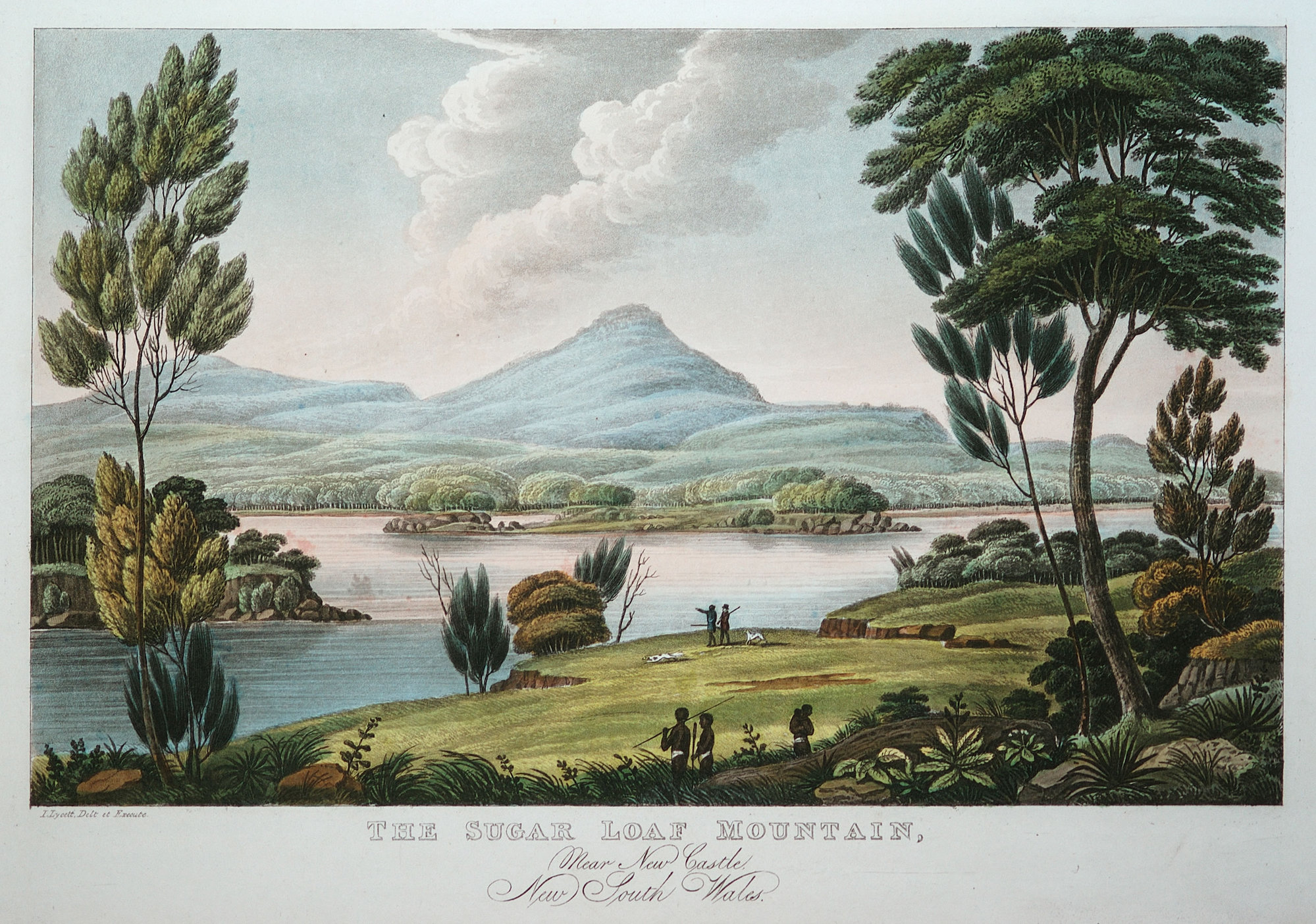
The Sugar Loaf Mountain, near New Castle, New South Wales, 1824 - by Joseph Lycett
- Placename
- Sugarloaf Mountain / Newcastle
- Type
- Other
Details
Description
CreatorLycett, Joseph, 1774-1828Description
1824 Joseph Lycett (c1774/75 - 1828)
The Sugarloaf Mountain, near Newcastle, New South Wales. 1824.
Aquatint etching, hand coloured. Sheet: 26.1 x 36.1 Plate: 23.0 x 32.3 Image: 17.1 x 27.0 Inscribed: printed in the plate margins, l.l. "I.Lycett, Delt et Execute."; lower c. "THE SUGAR LOAF MOUNTAIN,/Near New Castle, /New South Wales./ London, Published Octr.1, 1824, by J. Souter, 73, St. Pauls Church Yard."
Purchased 1968 1968:38
Courtesy Newcastle Region Art Gallery
Flickr Comment
barraba: I have this same etching which I wish to sell
SubjectMount Sugarloaf (N.S.W.)Mt. Sugarloaf (N.S.W.)Newcastle (N.S.W.)Date1924
Sources
https://livinghistories.newcastle.edu.au/nodes/view/44218