Gazetteer of Historical Australian Places
Layer
| Name | Virtual Coquun-Hunter River Project Guide: 1801 - 1820 |
|---|---|
| Description | Chronological list of descriptive accounts of the Coquun - Hunter River Region: 1801 - 1820
|
| Type | Other |
| Content Warning | |
| Contributor | Shellie Smith |
| Entries | 13 |
| Allow ANPS? | No |
| Added to System | 2024-03-22 10:45:56 |
| Updated in System | 2024-04-24 10:24:36 |
| Subject | |
|---|---|
| Creator | |
| Publisher | |
| Contact | |
| Citation | |
| DOI | |
| Source URL | https://libguides.newcastle.edu.au/chrp/1801-1820 |
| Linkback | |
| Date From | |
| Date To | |
| Image |
| Latitude From | |
|---|---|
| Longitude From | |
| Latitude To | |
| Longitude To | |
| Language | |
| License | |
| Usage Rights | |
| Date Created (externally) |
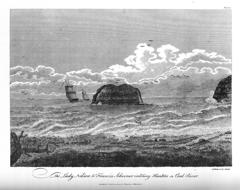
1801 Lieutenant James Grant
- Placename
- Newcastle / Hunter River / Ash Island
- Type
- Event
Details
Description
1801 Lieutenant James Grant
The presence of coal was the first of the natural resources that caught the eye of the European visitors to the region. Newcastle was officially discovered by Lieutenant John Shortland in 1797, but there is evidence that in 1791 a group of convicts who had escaped had "there found a quantity of fine burng (sic) coal", thus being, arguably, the first Europeans to discover coal in Australia. (see the 1791 account of James Martin above). In 1796 there were fishermen collecting coal pieces in the area and a number of individuals began selling it in Sydney. The interest generated within government circles in Sydney inspired Governor King to send an exploration party to the Hunter in June 1801 led by Lieutenant Grant and Lieutenant-Colonel Paterson to report on "where the most eligible place would be to form a settlement, both with respect to procuring coals and for agricultural purposes". Their report informed the Governor of the alluvial flats as being "a very fit situation for forming a settlement for the cultivation of grain or grazing". They also reported on the presence of oyster shells along the beaches as well as good quality timber along the river. A small party were left behind to mine the coal at the present site of Newcastle, but due to the misconduct of a commanding officer the small settlement that had been working the seams was abandoned in 1802.
Please read Lieutenant James Grant's account of his visit to Hunter's River and Ash Island with some general observations of the Aboriginal people (PDF) from The narrative of a voyage of discovery performed in his majesty's vessel the Lady Nelson of sixty tons burthen, with sliding keels; in the years 1800, 1801, and 1802, to New South Wales [pp.149 - 172] The engraved plates are below.
Please note that (according to T.M. Perry Australia's First Frontier: The Spread of Settlement in New South Wales 1788 - 1829 Melbourne University Press 1963 p.56 note 8) they "regarded the Williams as the main stream and refer to it as the Hunter in their reports. The Hunter upstream from its confluence with the Williams they named the Paterson. Although the confluence of the (present) Paterson and Hunter was shown on their map, they did not explore the Paterson."
References:
Grant, James, 1772-1833. The narrative of a voyage of discovery, performed in His Majesty's vessel the Lady Nelson, of sixty tons burthen, with sliding keels, in the years 1800, 1801 and 1802, to New South Wales. To which is prefixed, An account of the origin of sliding keels .. London : Printed by C. Roworth … for T. Egerton …, 1803.
AUCH - RB/COLL STACK/FOYER Q994.02/29 B
Grant, James, 1772-1833. The narrative of a voyage of discovery, performed in His Majesty's vessel The Lady Nelson, of sixty tons burthen, with sliding keels, in the years 1800, 1801, and 1802, to New South Wales. [Adelaide : Libraries Board of South Australia, 1973] Facsimile ed. Auch - Quarto Book Q994.402 GRAN
Professor Ross Deamer adds:
"In 1801 Gov. Hunter realised the need for the exploration of the Hunter River and ordered an expedition thence under the command of Col. William Paterson.
The expedition landed [1] on 14th June, 1801, at what Paterson was to call Coal Island, but now known as Nobby's Island.
Until June 28th the party was variously engaged in collecting coals, surveying the harbour and entrance thereto and exploring and mapping the channels and islands in the lower reaches up as far as and including Ash Island.[2]
Paterson formed the opinion that the Government would derive advantages by forming a settlement in the area so that organised mining operations may be commenced. He also recommended the area for the manufacture of salt, lime from burning the abundance of oyster shells, the salting of fish which were plentiful and for the despasturing of cattle.
On 29th June, a group proceeded up the river to Green Hills (now Raymond Terrace) where they spent the night and then instead of continuing up what appears from a boat to be the main stream, the Williams, then known as the Hunter, they entered the Paterson River (now the Hunter), which, Col. Paterson states had previously been known as the Cedar Arm. This would indicate that some adventurous souls had previously been along it for what was to be termed, the "red gold".
Paterson was to work up the river to what is now known as Mt Hudson, but was called by him Mt Anne, in honour of the Governor's wife. From the description of the journey the furtherest point reached by the expedition was some two miles beyond the "Dalwood Homestead", or the northeast corner of what was to be Maziere's grant.
The Report, submitted by Paterson upon his return, also stressed that the river flats beyond Green Hills were extremely suitable for agriculture and were well wooded with cedar, Ash and Box timbers of which there was a dearth in the known area of the colony.
[1] Paterson, Lt., Col., to Gov. King, 11th August 1801 - King Papers, Mitchell Library.
[2] Paterson's Journal, Mitchell Library."
Transcribed from: Deamer, Ross M Houses erected on original land grants in the Lower Hunter, Paterson and Williams River Valleys between 1800-1850 [manuscript] / Ross M. Deamer. University of Newcastle 1971 Auchmuty - Thesis THESIS 309 [pp.3-5]
Please click below for scanned excerpts from the Historical Records of New South Wales, Volume 4 Edited by F.M. Bladen Sydney 1896:
- 1801, 14th June - Report on Hunter River by Lieutenant James Grant, Commander pp. 404 - 409
- 1801, 24th June - Ensign Barrallier to Governor King. (King Papers) pp.413 - 414
- 1801, 25th June - Lieutenant-Colonel Paterson to Governor King. (King Papers) pp.414 - 416
- 1801, 25th June - Surgeon Harris to Governor King. (King Papers) pp.416 - 418
- 1801, 11th August - Lieut. - Colonel Paterson to Governor King (King Papers) pp.447 - 448 and Lieutenant - Colonel Paterson's Journal and Discoveries at Hunter River pp. 448 - 453
- 1801, 21st November- Mr M. Mason to Governor King (King papers) pp. 627 - 628
- 1801, 11th December - Mr Surveyor Grimes on Hunter's River pp.634 - 635
Sources
1802 Francis Barrallier
- Placename
- Newcastle / Hunter River
- Type
- Other
Details
Description
Barrallier, Francis, 1773-1853. Letter received by Banks from Charles Francis Greville, April 1802 (Series 23.25) Includes Greville's translation of a letter received by Greville from Francis Barrallier titled `Extract from Ensign Barralliers Letter to Mr Greville', ca April 1802. Contains a description of the entrance to Hunters River and Patersons River, with descriptions of the Natives seen there. [Sir Joseph Banks' Papers ] State Library of New South Wales.
Sources
1804 David Collins
- Placename
- Newcastle
- Type
- Other
Details
Description
1804 David Collins
In relation to the escaped convicts please read excerpts from Collins' account in the first edition 1798 V.1 pp.484 - 485 and 1802 V.2 pp. 47-48 as a PDF file .
Collins, David, 1756-1810. An account of the English colony in New South Wales : with remarks on the dispositions, customs, manners, &c. of the native inhabitants of that country / by David Collins. To which are added, some particulars of New Zealand, compiled, by permission from the mss. of Lieutenant-Governor King. London : Printed for T. Cadell Jun. and W. Davies, 1798 AUCH - RB/COLL STACK/FOYE Q994.02/14
(1st edition: unfortunately we possess Vol 1 only. We do have complete sets of the facsimile editions though. see V.1 p. 484, V.2 p.48)
Collins, David, 1756-1810. An account of the English colony in New South Wales from its first settlement in January 1788 to August 1801 : with remarks on the dispositions, customs, manners &c. of the native inhabitants of that country : to which are added some particulars of New Zealand, compiled … from the Mss. of Lieutenant-Governor King, and an account of a voyage performed by Captain Flinders and Mr. Bass … abstracted from the journal of Mr. Bass. London : Printed by A. Strahan … for T. Cadell and W. Davies …, 1804 2nd ed [see pp. 302-305?] AUCH - RB/COLL STACK/FOYE Q994.02/27
Sources
1805 John Platt
- Placename
- Newcastle
- Type
- Other
Details
Description
1805 John Platt
1805, May 5th Sydney Gazette, Account given by John Platt, a coal miner of the coal mines at Newcastle. [Original and Transcription]
Sources
1811-1812 Lachlan Macquarie
- Placename
- Newcastle / Port Stephens
- Type
- Event
Details
Description
1811-1812 Lachlan Macquarie.
Macquarie University have created transcriptions of the Journals of Elizabeth and Lachlan Macquarie through the magnificent project entitled Journeys in Time 1809 - 1822.
Please click here for their Extract from: Journal to and from Van Diemen's/ Land to Sydney in N.S. Wales. which records the account of a voyage made by Lachlan and Elizabeth Macquarie in the period 26 December 1811- 6 January 1812 on board the Lady Nelson from Van Diemen's Land to Port Stephens and Newcastle; the details of the Tour of Inspection; and the return journey to Sydney.
Sources
1811 David Mann
- Type
- Other
Details
Description
Mann, D. D. (David Dickenson). The present picture of New South Wales. London : Sold by John Booth, 1811. AUCH - RB/COLL AUROUSS Q994.4/40
Mann, D. D. (David Dickenson). The present picture of New South Wales, 1811 / by D.D. Mann with an introduction by Brian Fletcher. Sydney : John Ferguson in association with Royal Australian Historical Society, 1979. Auch - Quarto Book Q994.4/40 B and Auch - Quarto Book Q994.4/40 C and Open Stack - BLUE Q994.402/M2.
Click for The Project Gutenberg EBook of The Present Picture of New South Wales (1811), by David Dickinson Mann. Produced by Col Choat.
Sources
1818 Sophia Campbell / Edward Close Paintings
- Placename
- Newcastle
- Type
- Other
Details
Description
Digital Images of Sophia Campbell's paintings of Newcastle are available from the National Library of Australia's Pictures Catalogue.
See below for reattribution
https://www.daao.org.au/bio/sophia-campbell/biography/
Formerly regarded as a watercolour painter and sketcher and as Australia’s first woman artist.
A sketchbook of unsigned drawings, 'Sketchbook of scenes of Sydney, Broken Bay, Newcastle and region, New South Wales, 1817-1840’, held by the National Library of Australia, was attributed to Sophia Campbell until 2009 on the basis of family tradition and a letter written to Sir John Ferguson. The letter, from Sydney barrister V.J. Rundell Miles and dated 21 November 1922, offered the sketchbook to Ferguson for 60 pounds. It noted “I believe the painter was the wife of merchant Campbell of Duntroon. The book came from there” (National Library of Australia MS3200 Box 86 Folder 37). A second sketchbook, held in a private collection in the United Kingdom until 2009, had also been attributed to Sophia Campbell; it contained The costume of the Australasians as well as Sydney in all its glory, an untitled drawing of the Philo Free trial and drawings of the voyage of the Matilda in 1817.
In 2009 both sketchbooks were re-attributed to Edward Close, the husband of Sophia Campbell’s niece. The trigger for the re-attribution was the availability for examination in Australia, prior to auction at Sotheby’s Melbourne in May 2009, of the second sketchbook. Comparison with works by Edward Close held at the State Library of New South Wales revealed a very similar style. The inclusion of drawings from the voyage of the Matilda also supported the re-attribution to Close, who accompanied his regiment to New South Wales on the Matilda in 1817. In that year, Sophia Campbell was recorded as living in Sydney i.e. she could not have created eye-witness drawings from the voyage of the Matilda. The provenance of the album auctioned at Sotheby’s was through the Campbell family, but this can be readily explained by the fact that Edward Close’s daughter Marrianne married a Campbell.
The re-attribution of the album auctioned at Sotheby’s in turn led to the re-attribution of the sketchbook in the National Library, which has the same size, binding, watermark and stationer’s label as the Matilda sketchbook and is very similar in style. Other evidence for the re-attribution of the sketchbook in the National Library included the presence of a painting of Morpeth which shows a completed St James Church in the distance. Building of the church commenced in 1837, three years after Sophia Campbell’s death. Edward Close is recorded as resident in Morpeth from 1821-66; he funded the costs of building St James’ Church.
The album auctioned at Sotheby’s was acquired by the State Library of New South Wales.
These re-attributions removed all known evidence that Sophia Campbell was an artist.
Writers:Groom, Linda Note:Date written:2009Last updated:2011Status:peer-reviewed
Sources
1818 Lachlan Macquarie
- Placename
- Newcastle
- Type
- Other
Details
Description
Macquarie University have created transcriptions of the Journals of Elizabeth and Lachlan Macquarie through the magnificent project entitled Journeys in Time 1809 - 1822 .
Please click here for transcription of Lachlan Macquarie: Journal to and from Newcastle. 27 July 1818 - 9 August 1818 which records the account of the voyage to Newcastle on board the brig Elizabeth Henrietta to determine the resources and state of the settlement, and to explore the three branches of the Hunter River. The commandant at Newcastle was Captain James Wallis (46th Regiment).
Sources
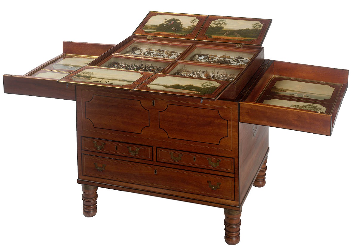
1818 Macquarie Collector's Chest, ca. 1818
- Placename
- Newcastle
- Type
- Other
Details
Description
The Strathallan collector's chest, which includes numerous views of Newcastle is at:
Sources
1819 John Slater
- Placename
- Newcastle
- Type
- Other
Details
Description
Slater, John, fl. 1817-1818 A description of Sydney, Parramatta, Newcastle, &c. settlements in New South Wales, with some account of the manners and employment of the convicts in a letter from John Slater, to his wife in Nottingham, published for the benefit of his wife and four children. Canberra : National Library of Australia, c1988
AUCH - RB/COLL Pam365.3409944/1.Please read our online version of John Slater's Letter courtesy of the National Library of Australia.
Slater, John, fl. 1817-1818 John Slater's letter / by Douglas H. Pike[1952?]
AUCH - RB/COLL GRAY 919.4402/2
Sources
1819 William Charles Wentworth
- Placename
- Newcastle / Coal River
- Type
- Other
Details
Description
Wentworth, W. C. (William Charles), 1790-1872. A statistical, historical, and political description of the colony of New South Wales and its dependent settlements in Van Diemen's Land : with a particular enumeration of the advantages which these colonies offer for emigration, and their superiority in many respects over those possessed by the United States of America / by W.C. Wentworth. London : Printed for G. and W.B. Whittaker, 1819. [Shelf Location: AUCH - RB/COLL994.4/13and AUCH - RB/COLL ELLIS994.4/13 B.
Please read Wentworth's account (PDF) of Coal River (pp. 54 - 60) and some supplementary remarks upon the administration of Governor Bligh during the period.
Sources
1820 Joseph Lycett
- Placename
- Newcastle
- Type
- Other
Details
Description
1820 Joseph Lycett
Lycett, Joseph, ca. 1775-1828. Views in Australia or New South Wales & Van Diemen's Land delineated, in fifty views, with descriptive letter prefs., by J. Lycett. London, J. Souter, 1824 [-1825]. Melbourne, Thomas Nelson (Australia) 1971] Shelf Location: AUCH - RB/COLL F919.44042 LYCE 1971
Lycett, Joseph, ca. 1775-1828. The Lycett album : drawings of Aborigines and Australian scenery / with commentary by Jeanette Hoorn. Canberra : National Library of Australia, 1990. Shelf Location: Huxley-Book 741.994 LYCE-1 LYCE 1990
Turner, John. Joseph Lycett : Governor Macquarie's convict artist. Newcastle, N.S.W. : Hunter History Publications, 1997. Shelf Location: Auch - Quarto Book Q759.994 LYCE-2 TURN, AUCH - RB/COLL STAFFQ759.994 LYCE-2 TURNc.2 and Central Coast - Quarto Book Q759.994 LYCE-2 TURNc.3
Sources
1820 Joseph Lycett
- Placename
- Newcastle
- Type
- Other
Details
Description
Lycett landscapes of Hunter River estuary: on panels of the Dixson Galleries Collector’s chest in the State Library. [There is also a second collectors chest with similar landscapes c 1820, is held privately in Sydney]
https://www.sl.nsw.gov.au/collection-items/dixson-collectors-chest-0

